Uchaux geodata
Uchaux (Provence-Alpes-Côte d'Azur) is a populated place; located in France in Europe/Paris (GMT+2) time zone. With population of 1,576 people, there are 5911 cities with bigger population in this country. Compared to other cities in France, 85.4% of cities are located further ↑North; 75% of cities are located further ←West and 54.4% of cities have higher elevation than Uchaux. Note1
Administrative division(s):
- Level 1: Provence-Alpes-Côte d'Azur
- Level 2: Département du Vaucluse
- Level 3: Arrondissement de Carpentras
- Level 4: Uchaux


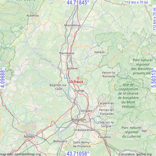
Uchaux GPS coordinates[2]
44° 13' 0.012" North, 4° 48' 0" East
| Map corner | latitude | longitude |
|---|---|---|
| Upper-left | 44.71845°, | 4.09688° |
| Center: | 44.21667°, | 4.8° |
| Lower-right: | 43.71058°, | 5.50313° |
| Map W x H: | 112.1×112.1 km | = 69.7×69.7mi |
| max Lat: | 51.07786° ⇑85.4% North |
| Uchaux: | 44.21667° |
| min Lat: | ⇓14.6% South 41.3874° |
| min Long | Uchaux | max Long |
| -5.08615° | 4.8° | 9.52242° |
| W 75%⇐ | ⇒25% E |
Elevation
Elevation of Uchaux is 118 m = 387 ft, and this is 75.7 m = 248 ft below average elevation for this country.
| Max E: |
2333 m = 7654 ft | 54.4% |
| Avg. | 193.7 m = 635 ft | |
| Uchaux | 118 m = 387 ft | |
Min E: |
-1 m = -3 ft | 45.6% |
See also: France elevation on elevation.city.
Geographical zone
Uchaux is located in North temperate zone (between Tropic of Cancer and the Arctic Circle). Distance of this Northern Tropic circle is 2310.5 km =1435.7 mi to South.| Distance of | km | miles | from Uchaux |
|---|---|---|---|
| North Pole | 5090.6 | 3163.2 | to North |
| Arctic Circle | 2484.7 | 1543.9 | to North |
| Tropic Cancer | 2310.5 | 1435.7 | to South |
| Equator | 4916.4 | 3054.9 | to South |


Nearby cities:
15 places around Uchaux: (largest is in red/bold)
• Bollène
8.3 km =5.2 mi,  330°
330°
• Bouchet
10.9 km =6.8 mi,  32°
32°
• Cairanne
10.7 km =6.6 mi,  80°
80°
• Camaret-sur-Aigues
8.3 km =5.2 mi,  135°
135°
• Mondragon
7.3 km =4.5 mi,  289°
289°
• Mornas
6 km =3.7 mi,  254°
254°
• Orange
8.8 km =5.5 mi,  174°
174°
• Piolenc
5.3 km =3.3 mi,  215°
215°
• Rochegude
3.7 km =2.3 mi,  35°
35°
• Saint-Étienne-des-Sorts
8.3 km =5.2 mi, 245°
• Sainte-Cécile-les-Vignes
7.6 km =4.7 mi,  65°
65°
• Suze-la-Rousse
8.6 km =5.3 mi,  22°
22°
• Sérignan-du-Comtat
4.6 km =2.9 mi,  131°
131°
• Travaillan
8.9 km =5.5 mi,  114°
114°
• Vénéjan
11.8 km =7.3 mi,  259°
259°
Sources, notices
• [Note1] Compared only with cities in France existing in our database
• [Src1] Map data: © OpenStreetMap contributors (CC-BY-SA)
• [Src2] Other city data from geonames.org with taken over terms of usage.
• [Src3] Geographical zone / Annual Mean Temperature by Robert A. Rohde @ Wikipedia
