Vénéjan geodata
Vénéjan (Occitanie) is a populated place; located in France in Europe/Paris (GMT+2) time zone. With population of 1,145 people, there are 7854 cities with bigger population in this country. Compared to other cities in France, 85.5% of cities are located further ↑North; 73.3% of cities are located further ←West and 69.7% of cities have higher elevation than Vénéjan. Note1
Administrative division(s):
- Level 1: Occitanie
- Level 2: Gard
- Level 3: Arrondissement de Nîmes
- Level 4: Vénéjan


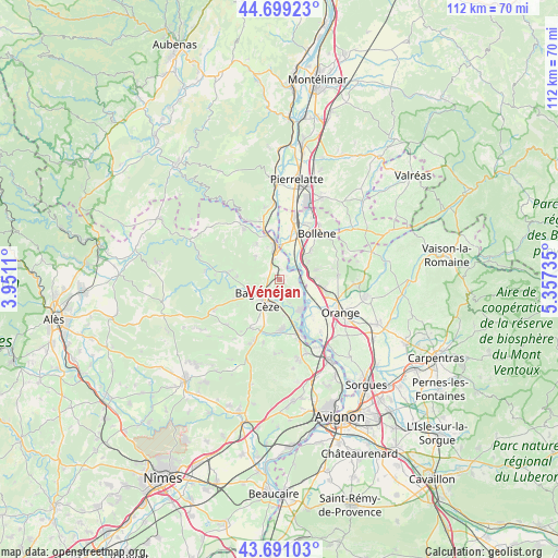
Vénéjan GPS coordinates[2]
44° 11' 50.244" North, 4° 39' 15.192" East
| Map corner | latitude | longitude |
|---|---|---|
| Upper-left | 44.69923°, | 3.9511° |
| Center: | 44.19729°, | 4.65422° |
| Lower-right: | 43.69103°, | 5.35735° |
| Map W x H: | 112.1×112.1 km | = 69.7×69.7mi |
| max Lat: | 51.07786° ⇑85.5% North |
| Vénéjan: | 44.19729° |
| min Lat: | ⇓14.5% South 41.3874° |
| min Long | Vénéjan | max Long |
| -5.08615° | 4.65422° | 9.52242° |
| W 73.3%⇐ | ⇒26.7% E |
Elevation
Elevation of Vénéjan is 79 m = 259 ft, and this is 114.7 m = 376 ft below average elevation for this country.
| Max E: |
2333 m = 7654 ft | 69.7% |
| Avg. | 193.7 m = 635 ft | |
| Vénéjan | 79 m = 259 ft | |
Min E: |
-1 m = -3 ft | 30.3% |
See also: France elevation on elevation.city.
Geographical zone
Vénéjan is located in North temperate zone (between Tropic of Cancer and the Arctic Circle). Distance of this Northern Tropic circle is 2308.4 km =1434.4 mi to South.| Distance of | km | miles | from Vénéjan |
|---|---|---|---|
| North Pole | 5092.8 | 3164.5 | to North |
| Arctic Circle | 2486.9 | 1545.3 | to North |
| Tropic Cancer | 2308.4 | 1434.4 | to South |
| Equator | 4914.3 | 3053.6 | to South |


Nearby cities:
15 places around Vénéjan: (largest is in red/bold)
• Bagnols-sur-Cèze
5.1 km =3.2 mi,  214°
214°
• Carsan
6.2 km =3.9 mi,  311°
311°
• Chusclan
5.9 km =3.7 mi,  158°
158°
• Codolet
8.9 km =5.5 mi, 156°
• Mondragon
6.5 km =4 mi,  45°
45°
• Mornas
5.9 km =3.7 mi,  84°
84°
• Orsan
7.4 km =4.6 mi,  173°
173°
• Piolenc
8.8 km =5.5 mi,  104°
104°
• Pont-Saint-Esprit
6.4 km =4 mi,  355°
355°
• Sabran
9.9 km =6.2 mi,  238°
238°
• Saint-Alexandre
4.3 km =2.7 mi,  321°
321°
• Saint-Gervais
6.4 km =4 mi,  256°
256°
• Saint-Nazaire
2.4 km =1.5 mi,  272°
272°
• Saint-Paulet-de-Caisson
8.3 km =5.2 mi,  327°
327°
• Saint-Étienne-des-Sorts
4.3 km =2.7 mi,  107°
107°
Sources, notices
• [Note1] Compared only with cities in France existing in our database
• [Src1] Map data: © OpenStreetMap contributors (CC-BY-SA)
• [Src2] Other city data from geonames.org with taken over terms of usage.
• [Src3] Geographical zone / Annual Mean Temperature by Robert A. Rohde @ Wikipedia
