Mornas geodata
Mornas (Provence-Alpes-Côte d'Azur) is a populated place; located in France in Europe/Paris (GMT+2) time zone. With population of 2,370 people, there are 4081 cities with bigger population in this country. Compared to other cities in France, 85.5% of cities are located further ↑North; 74.1% of cities are located further ←West and 57.3% of cities have higher elevation than Mornas. Note1
Administrative division(s):
- Level 1: Provence-Alpes-Côte d'Azur
- Level 2: Département du Vaucluse
- Level 3: Arrondissement de Carpentras
- Level 4: Mornas


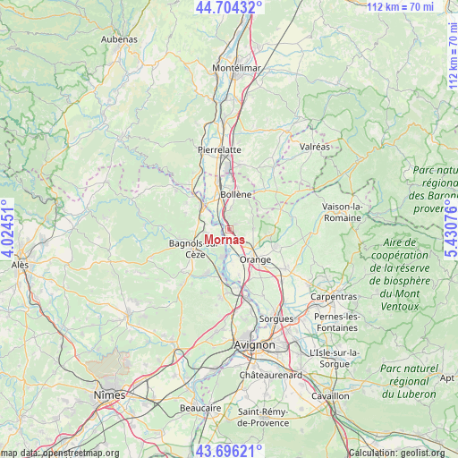
Mornas GPS coordinates[2]
44° 12' 8.712" North, 4° 43' 39.468" East
| Map corner | latitude | longitude |
|---|---|---|
| Upper-left | 44.70432°, | 4.02451° |
| Center: | 44.20242°, | 4.72763° |
| Lower-right: | 43.69621°, | 5.43076° |
| Map W x H: | 112.1×112.1 km | = 69.7×69.7mi |
| max Lat: | 51.07786° ⇑85.5% North |
| Mornas: | 44.20242° |
| min Lat: | ⇓14.5% South 41.3874° |
| min Long | Mornas | max Long |
| -5.08615° | 4.72763° | 9.52242° |
| W 74.1%⇐ | ⇒25.9% E |
Elevation
Elevation of Mornas is 110 m = 361 ft, and this is 83.7 m = 275 ft below average elevation for this country.
| Max E: |
2333 m = 7654 ft | 57.3% |
| Avg. | 193.7 m = 635 ft | |
| Mornas | 110 m = 361 ft | |
Min E: |
-1 m = -3 ft | 42.7% |
See also: France elevation on elevation.city.
Geographical zone
Mornas is located in North temperate zone (between Tropic of Cancer and the Arctic Circle). Distance of this Northern Tropic circle is 2308.9 km =1434.7 mi to South.| Distance of | km | miles | from Mornas |
|---|---|---|---|
| North Pole | 5092.2 | 3164.1 | to North |
| Arctic Circle | 2486.3 | 1544.9 | to North |
| Tropic Cancer | 2308.9 | 1434.7 | to South |
| Equator | 4914.8 | 3053.9 | to South |


Nearby cities:
15 places around Mornas: (largest is in red/bold)
• Bollène
8.9 km =5.5 mi,  10°
10°
• Chusclan
7.1 km =4.4 mi,  211°
211°
• Codolet
9.1 km =5.7 mi,  195°
195°
• Mondragon
4.2 km =2.6 mi,  343°
343°
• Orange
9.7 km =6 mi,  137°
137°
• Orsan
9.4 km =5.8 mi, 212°
• Piolenc
3.9 km =2.4 mi, 135°
• Pont-Saint-Esprit
8.7 km =5.4 mi,  312°
312°
• Rochegude
9.2 km =5.7 mi,  59°
59°
• Saint-Alexandre
9 km =5.6 mi,  288°
288°
• Saint-Nazaire
8.3 km =5.2 mi,  266°
266°
• Saint-Étienne-des-Sorts
2.6 km =1.6 mi,  223°
223°
• Sérignan-du-Comtat
9.4 km =5.8 mi,  99°
99°
• Uchaux
6 km =3.7 mi,  74°
74°
• Vénéjan
5.9 km =3.7 mi,  264°
264°
Sources, notices
• [Note1] Compared only with cities in France existing in our database
• [Src1] Map data: © OpenStreetMap contributors (CC-BY-SA)
• [Src2] Other city data from geonames.org with taken over terms of usage.
• [Src3] Geographical zone / Annual Mean Temperature by Robert A. Rohde @ Wikipedia
