Mondragon geodata
Mondragon (Provence-Alpes-Côte d'Azur) is a populated place; located in France in Europe/Paris (GMT+2) time zone. With population of 3,583 people, there are 2723 cities with bigger population in this country. Compared to other cities in France, 85.2% of cities are located further ↑North; 73.9% of cities are located further ←West and 60.4% of cities have higher elevation than Mondragon. Note1
Administrative division(s):
- Level 1: Provence-Alpes-Côte d'Azur
- Level 2: Département du Vaucluse
- Level 3: Arrondissement de Carpentras
- Level 4: Mondragon


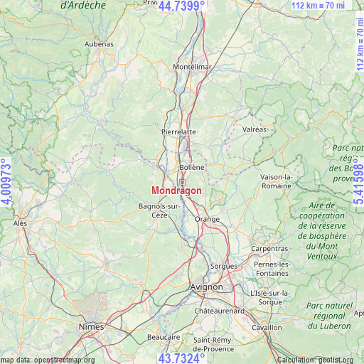
Mondragon GPS coordinates[2]
44° 14' 17.916" North, 4° 42' 46.296" East
| Map corner | latitude | longitude |
|---|---|---|
| Upper-left | 44.7399°, | 4.00973° |
| Center: | 44.23831°, | 4.71286° |
| Lower-right: | 43.7324°, | 5.41598° |
| Map W x H: | 112×112 km | = 69.6×69.6mi |
| max Lat: | 51.07786° ⇑85.2% North |
| Mondragon: | 44.23831° |
| min Lat: | ⇓14.8% South 41.3874° |
| min Long | Mondragon | max Long |
| -5.08615° | 4.71286° | 9.52242° |
| W 73.9%⇐ | ⇒26.1% E |
Elevation
Elevation of Mondragon is 101 m = 331 ft, and this is 92.7 m = 304 ft below average elevation for this country.
| Max E: |
2333 m = 7654 ft | 60.4% |
| Avg. | 193.7 m = 635 ft | |
| Mondragon | 101 m = 331 ft | |
Min E: |
-1 m = -3 ft | 39.6% |
See also: France elevation on elevation.city.
Geographical zone
Mondragon is located in North temperate zone (between Tropic of Cancer and the Arctic Circle). Distance of this Northern Tropic circle is 2312.9 km =1437.2 mi to South.| Distance of | km | miles | from Mondragon |
|---|---|---|---|
| North Pole | 5088.2 | 3161.7 | to North |
| Arctic Circle | 2482.3 | 1542.4 | to North |
| Tropic Cancer | 2312.9 | 1437.2 | to South |
| Equator | 4918.8 | 3056.4 | to South |


Nearby cities:
15 places around Mondragon: (largest is in red/bold)
• Bollène
5.6 km =3.5 mi,  31°
31°
• Carsan
9.3 km =5.8 mi,  267°
267°
• Chusclan
10.3 km =6.4 mi,  194°
194°
• Lapalud
7.9 km =4.9 mi,  346°
346°
• Mornas
4.2 km =2.6 mi,  163°
163°
• Piolenc
7.8 km =4.8 mi,  150°
150°
• Pont-Saint-Esprit
5.5 km =3.4 mi,  289°
289°
• Rochegude
9.1 km =5.7 mi,  85°
85°
• Saint-Alexandre
7.4 km =4.6 mi,  260°
260°
• Saint-Just-d'Ardèche
10.3 km =6.4 mi,  311°
311°
• Saint-Nazaire
8.4 km =5.2 mi,  237°
237°
• Saint-Paulet-de-Caisson
9.5 km =5.9 mi, 285°
• Saint-Étienne-des-Sorts
5.9 km =3.7 mi, 185°
• Uchaux
7.3 km =4.5 mi,  109°
109°
• Vénéjan
6.5 km =4 mi,  225°
225°
Sources, notices
• [Note1] Compared only with cities in France existing in our database
• [Src1] Map data: © OpenStreetMap contributors (CC-BY-SA)
• [Src2] Other city data from geonames.org with taken over terms of usage.
• [Src3] Geographical zone / Annual Mean Temperature by Robert A. Rohde @ Wikipedia
