Caderousse geodata
Caderousse (Provence-Alpes-Côte d'Azur) is a populated place; located in France in Europe/Paris (GMT+2) time zone. With population of 2,663 people, there are 3665 cities with bigger population in this country. Compared to other cities in France, 86.2% of cities are located further ↑North; 74.4% of cities are located further ←West and 89.1% of cities have higher elevation than Caderousse. Note1
Administrative division(s):
- Level 1: Provence-Alpes-Côte d'Azur
- Level 2: Département du Vaucluse
- Level 3: Arrondissement de Carpentras
- Level 4: Caderousse


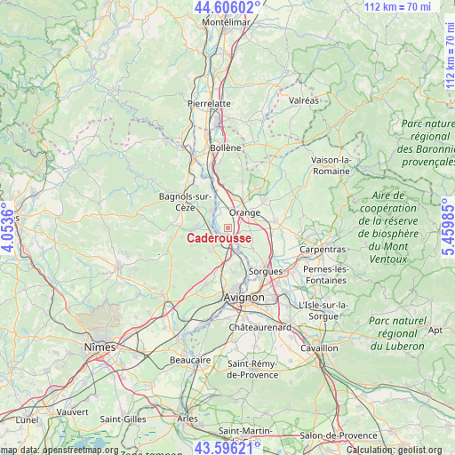
Caderousse GPS coordinates[2]
44° 6' 11.772" North, 4° 45' 24.192" East
| Map corner | latitude | longitude |
|---|---|---|
| Upper-left | 44.60602°, | 4.0536° |
| Center: | 44.10327°, | 4.75672° |
| Lower-right: | 43.59621°, | 5.45985° |
| Map W x H: | 112.3×112.3 km | = 69.8×69.8mi |
| max Lat: | 51.07786° ⇑86.2% North |
| Caderousse: | 44.10327° |
| min Lat: | ⇓13.8% South 41.3874° |
| min Long | Caderousse | max Long |
| -5.08615° | 4.75672° | 9.52242° |
| W 74.4%⇐ | ⇒25.6% E |
Elevation
Elevation of Caderousse is 32 m = 105 ft, and this is 161.7 m = 531 ft below average elevation for this country.
| Max E: |
2333 m = 7654 ft | 89.1% |
| Avg. | 193.7 m = 635 ft | |
| Caderousse | 32 m = 105 ft | |
Min E: |
-1 m = -3 ft | 10.9% |
See also: France elevation on elevation.city.
Geographical zone
Caderousse is located in North temperate zone (between Tropic of Cancer and the Arctic Circle). Distance of this Northern Tropic circle is 2297.9 km =1427.8 mi to South.| Distance of | km | miles | from Caderousse |
|---|---|---|---|
| North Pole | 5103.2 | 3171 | to North |
| Arctic Circle | 2497.4 | 1551.8 | to North |
| Tropic Cancer | 2297.9 | 1427.8 | to South |
| Equator | 4903.8 | 3047.1 | to South |


Nearby cities:
15 places around Caderousse: (largest is in red/bold)
• Chusclan
7.8 km =4.8 mi,  309°
309°
• Châteauneuf-du-Pape
8 km =5 mi,  130°
130°
• Codolet
5.2 km =3.2 mi,  295°
295°
• Laudun-l'Ardoise
7.2 km =4.5 mi,  267°
267°
• Lirac
9.4 km =5.8 mi,  216°
216°
• Montfaucon
3.4 km =2.1 mi,  182°
182°
• Orange
5.8 km =3.6 mi,  47°
47°
• Orsan
7.9 km =4.9 mi,  292°
292°
• Piolenc
8.3 km =5.2 mi,  2°
2°
• Roquemaure
6.2 km =3.9 mi,  164°
164°
• Saint-Geniès-de-Comolas
5 km =3.1 mi,  214°
214°
• Saint-Laurent-des-Arbres
7 km =4.3 mi, 219°
• Saint-Victor-la-Coste
10.2 km =6.3 mi,  243°
243°
• Saint-Étienne-des-Sorts
10 km =6.2 mi,  336°
336°
• Sauveterre
9.4 km =5.8 mi, 161°
Sources, notices
• [Note1] Compared only with cities in France existing in our database
• [Src1] Map data: © OpenStreetMap contributors (CC-BY-SA)
• [Src2] Other city data from geonames.org with taken over terms of usage.
• [Src3] Geographical zone / Annual Mean Temperature by Robert A. Rohde @ Wikipedia
