Monségur geodata
Monségur (Nouvelle-Aquitaine) is a populated place; located in France in Europe/Paris (GMT+2) time zone. With population of 1,558 people, there are 5980 cities with bigger population in this country. Compared to other cities in France, 82.4% of cities are located further ↑North; 77.4% of cities are located further →East and 75.4% of cities have higher elevation than Monségur. Note1
Administrative division(s):
- Level 1: Nouvelle-Aquitaine
- Level 2: Gironde
- Level 3: Arrondissement de Langon
- Level 4: Monségur


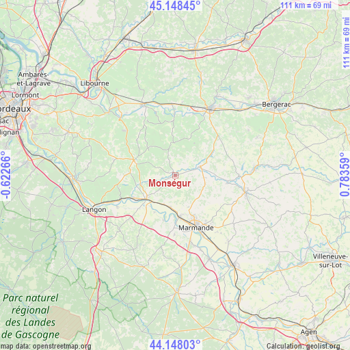
Monségur GPS coordinates[2]
44° 39' 1.44" North, 0° 4' 49.692" East
| Map corner | latitude | longitude |
|---|---|---|
| Upper-left | 45.14845°, | -0.62266° |
| Center: | 44.6504°, | 0.08047° |
| Lower-right: | 44.14803°, | 0.78359° |
| Map W x H: | 111.2×111.2 km | = 69.1×69.1mi |
| max Lat: | 51.07786° ⇑82.4% North |
| Monségur: | 44.6504° |
| min Lat: | ⇓17.6% South 41.3874° |
| min Long | Monségur | max Long |
| -5.08615° | 0.08047° | 9.52242° |
| W 22.6%⇐ | ⇒77.4% E |
Elevation
Elevation of Monségur is 66 m = 217 ft, and this is 127.7 m = 419 ft below average elevation for this country.
| Max E: |
2333 m = 7654 ft | 75.4% |
| Avg. | 193.7 m = 635 ft | |
| Monségur | 66 m = 217 ft | |
Min E: |
-1 m = -3 ft | 24.6% |
See also: France elevation on elevation.city.
Geographical zone
Monségur is located in North temperate zone (between Tropic of Cancer and the Arctic Circle). Distance of this Northern Tropic circle is 2358.7 km =1465.6 mi to South.| Distance of | km | miles | from Monségur |
|---|---|---|---|
| North Pole | 5042.4 | 3133.2 | to North |
| Arctic Circle | 2436.5 | 1514 | to North |
| Tropic Cancer | 2358.7 | 1465.6 | to South |
| Equator | 4964.7 | 3084.9 | to South |


Nearby cities:
15 places around Monségur: (largest is in red/bold)
• Beaupuy
13.9 km =8.6 mi,  156°
156°
• Blasimon
16.4 km =10.2 mi,  311°
311°
• Castelnau-sur-Gupie
11 km =6.8 mi, 157°
• Duras
8.6 km =5.3 mi,  70°
70°
• Fontet
13.4 km =8.3 mi,  221°
221°
• Gironde-sur-Dropt
15 km =9.3 mi,  240°
240°
• La Réole
12 km =7.5 mi,  230°
230°
• Lagupie
10.9 km =6.8 mi,  166°
166°
• Lévignac-de-Guyenne
9.8 km =6.1 mi,  104°
104°
• Meilhan-sur-Garonne
14.8 km =9.2 mi,  194°
194°
• Mongauzy
10 km =6.2 mi,  201°
201°
• Morizès
14.2 km =8.8 mi,  252°
252°
• Pellegrue
10.4 km =6.5 mi,  358°
358°
• Sainte-Bazeille
13.4 km =8.3 mi, 174°
• Sauveterre-de-Guyenne
14 km =8.7 mi,  289°
289°
Sources, notices
• [Note1] Compared only with cities in France existing in our database
• [Src1] Map data: © OpenStreetMap contributors (CC-BY-SA)
• [Src2] Other city data from geonames.org with taken over terms of usage.
• [Src3] Geographical zone / Annual Mean Temperature by Robert A. Rohde @ Wikipedia
