Aureville geodata
Aureville (Occitanie) is a populated place; located in France in Europe/Paris (GMT+2) time zone. With population of 611 people, there are 13143 cities with bigger population in this country. Compared to other cities in France, 93.3% of cities are located further ↑North; 63.6% of cities are located further →East and 67.6% of cities have lower elevation than Aureville. Note1
Administrative division(s):
- Level 1: Occitanie
- Level 2: Haute-Garonne
- Level 3: Arrondissement de Toulouse
- Level 4: Aureville


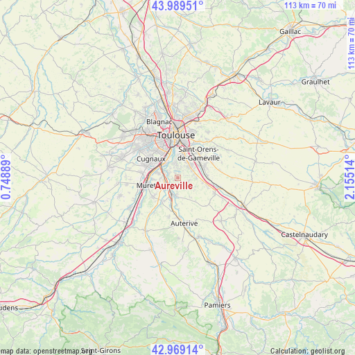
Aureville GPS coordinates[2]
43° 28' 53.328" North, 1° 27' 7.236" East
| Map corner | latitude | longitude |
|---|---|---|
| Upper-left | 43.98951°, | 0.74889° |
| Center: | 43.48148°, | 1.45201° |
| Lower-right: | 42.96914°, | 2.15514° |
| Map W x H: | 113.5×113.5 km | = 70.5×70.5mi |
| max Lat: | 51.07786° ⇑93.3% North |
| Aureville: | 43.48148° |
| min Lat: | ⇓6.7% South 41.3874° |
| min Long | Aureville | max Long |
| -5.08615° | 1.45201° | 9.52242° |
| W 36.4%⇐ | ⇒63.6% E |
Elevation
Elevation of Aureville is 207 m = 679 ft, and this is 13.3 m = 44 ft above average elevation for this country.
| Max E: |
2333 m = 7654 ft | 32.4% |
| Aureville | 207 m 679 ft | |
| Avg. | 193.7 m = 635 ft | |
Min E: |
-1 m = -3 ft | 67.6% |
See also: France elevation on elevation.city.
Geographical zone
Aureville is located in North temperate zone (between Tropic of Cancer and the Arctic Circle). Distance of this Northern Tropic circle is 2228.8 km =1384.9 mi to South.| Distance of | km | miles | from Aureville |
|---|---|---|---|
| North Pole | 5172.4 | 3214 | to North |
| Arctic Circle | 2566.5 | 1594.7 | to North |
| Tropic Cancer | 2228.8 | 1384.9 | to South |
| Equator | 4834.7 | 3004.1 | to South |


Nearby cities:
15 places around Aureville: (largest is in red/bold)
• Auzeville-Tolosane
5.7 km =3.5 mi,  25°
25°
• Castanet-Tolosan
5.4 km =3.4 mi,  44°
44°
• Clermont-le-Fort
3.9 km =2.4 mi,  221°
221°
• Corronsac
3.8 km =2.4 mi,  103°
103°
• Deyme
5.9 km =3.7 mi,  89°
89°
• Goyrans
1.7 km =1.1 mi,  274°
274°
• Labarthe-sur-Lèze
5.3 km =3.3 mi,  232°
232°
• Lacroix-Falgarde
4 km =2.5 mi,  300°
300°
• Pechbusque
5.3 km =3.3 mi,  3°
3°
• Pompertuzat
5.3 km =3.3 mi,  76°
76°
• Portet-sur-Garonne
5.9 km =3.7 mi,  321°
321°
• Péchabou
5.2 km =3.2 mi,  63°
63°
• Venerque
5.2 km =3.2 mi,  185°
185°
• Vieille-Toulouse
4.8 km =3 mi,  350°
350°
• Vigoulet-Auzil
2.9 km =1.8 mi,  12°
12°
Sources, notices
• [Note1] Compared only with cities in France existing in our database
• [Src1] Map data: © OpenStreetMap contributors (CC-BY-SA)
• [Src2] Other city data from geonames.org with taken over terms of usage.
• [Src3] Geographical zone / Annual Mean Temperature by Robert A. Rohde @ Wikipedia
