Vigoulet-Auzil geodata
Vigoulet-Auzil (Occitanie) is a populated place; located in France in Europe/Paris (GMT+2) time zone. With population of 997 people, there are 8849 cities with bigger population in this country. Compared to other cities in France, 93% of cities are located further ↑North; 63.5% of cities are located further →East and 76.1% of cities have lower elevation than Vigoulet-Auzil. Note1
Administrative division(s):
- Level 1: Occitanie
- Level 2: Haute-Garonne
- Level 3: Arrondissement de Toulouse
- Level 4: Vigoulet-Auzil


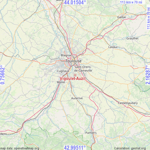
Vigoulet-Auzil GPS coordinates[2]
43° 30' 26.028" North, 1° 27' 35.064" East
| Map corner | latitude | longitude |
|---|---|---|
| Upper-left | 44.01504°, | 0.75662° |
| Center: | 43.50723°, | 1.45974° |
| Lower-right: | 42.99511°, | 2.16287° |
| Map W x H: | 113.4×113.4 km | = 70.5×70.5mi |
| max Lat: | 51.07786° ⇑93% North |
| Vigoulet-Auzil: | 43.50723° |
| min Lat: | ⇓7% South 41.3874° |
| min Long | Vigoulet-Auzil | max Long |
| -5.08615° | 1.45974° | 9.52242° |
| W 36.5%⇐ | ⇒63.5% E |
Elevation
Elevation of Vigoulet-Auzil is 257 m = 843 ft, and this is 63.3 m = 208 ft above average elevation for this country.
| Max E: |
2333 m = 7654 ft | 23.9% |
| Vigoulet-Auzil | 257 m 843 ft | |
| Avg. | 193.7 m = 635 ft | |
Min E: |
-1 m = -3 ft | 76.1% |
See also: France elevation on elevation.city.
Geographical zone
Vigoulet-Auzil is located in North temperate zone (between Tropic of Cancer and the Arctic Circle). Distance of this Northern Tropic circle is 2231.6 km =1386.7 mi to South.| Distance of | km | miles | from Vigoulet-Auzil |
|---|---|---|---|
| North Pole | 5169.5 | 3212.2 | to North |
| Arctic Circle | 2563.6 | 1592.9 | to North |
| Tropic Cancer | 2231.6 | 1386.7 | to South |
| Equator | 4837.6 | 3005.9 | to South |


Nearby cities:
15 places around Vigoulet-Auzil: (largest is in red/bold)
• Aureville
2.9 km =1.8 mi,  192°
192°
• Auzeville-Tolosane
2.9 km =1.8 mi,  38°
38°
• Castanet-Tolosan
3.3 km =2.1 mi,  72°
72°
• Clermont-le-Fort
6.6 km =4.1 mi,  209°
209°
• Corronsac
4.8 km =3 mi,  140°
140°
• Deyme
6 km =3.7 mi,  117°
117°
• Goyrans
3.6 km =2.2 mi,  220°
220°
• Lacroix-Falgarde
4.1 km =2.5 mi,  258°
258°
• Pechbusque
2.5 km =1.6 mi,  353°
353°
• Pinsaguel
5.8 km =3.6 mi,  273°
273°
• Pompertuzat
4.8 km =3 mi,  109°
109°
• Portet-sur-Garonne
4.7 km =2.9 mi,  292°
292°
• Péchabou
4 km =2.5 mi,  97°
97°
• Ramonville-Saint-Agne
4.5 km =2.8 mi,  15°
15°
• Vieille-Toulouse
2.3 km =1.4 mi,  322°
322°
Sources, notices
• [Note1] Compared only with cities in France existing in our database
• [Src1] Map data: © OpenStreetMap contributors (CC-BY-SA)
• [Src2] Other city data from geonames.org with taken over terms of usage.
• [Src3] Geographical zone / Annual Mean Temperature by Robert A. Rohde @ Wikipedia
