Payroux geodata
Payroux (Nouvelle-Aquitaine) is a populated place; located in France in Europe/Paris (GMT+2) time zone. With population of 531 people, there are 14589 cities with bigger population in this country. Compared to other cities in France, 63.3% of cities are located further ↑North; 73.5% of cities are located further →East and 56.3% of cities have lower elevation than Payroux. Note1
Administrative division(s):
- Level 1: Nouvelle-Aquitaine
- Level 2: Vienne
- Level 3: Arrondissement de Montmorillon
- Level 4: Payroux


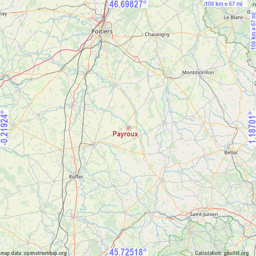
Payroux GPS coordinates[2]
46° 12' 49.968" North, 0° 29' 2.004" East
| Map corner | latitude | longitude |
|---|---|---|
| Upper-left | 46.69827°, | -0.21924° |
| Center: | 46.21388°, | 0.48389° |
| Lower-right: | 45.72518°, | 1.18701° |
| Map W x H: | 108.2×108.2 km | = 67.2×67.2mi |
| max Lat: | 51.07786° ⇑63.3% North |
| Payroux: | 46.21388° |
| min Lat: | ⇓36.7% South 41.3874° |
| min Long | Payroux | max Long |
| -5.08615° | 0.48389° | 9.52242° |
| W 26.5%⇐ | ⇒73.5% E |
Elevation
Elevation of Payroux is 155 m = 509 ft, and this is 38.7 m = 127 ft below average elevation for this country.
| Max E: |
2333 m = 7654 ft | 43.7% |
| Avg. | 193.7 m = 635 ft | |
| Payroux | 155 m = 509 ft | |
Min E: |
-1 m = -3 ft | 56.3% |
See also: France elevation on elevation.city.
Geographical zone
Payroux is located in North temperate zone (between Tropic of Cancer and the Arctic Circle). Distance of this North polar circle is 2262.7 km =1406 mi to North.| Distance of | km | miles | from Payroux |
|---|---|---|---|
| North Pole | 4868.6 | 3025.2 | to North |
| Arctic Circle | 2262.7 | 1406 | to North |
| Tropic Cancer | 2532.6 | 1573.7 | to South |
| Equator | 5138.5 | 3192.9 | to South |


Nearby cities:
15 places around Payroux: (largest is in red/bold)
• Availles-Limouzine
16.8 km =10.4 mi,  128°
128°
• Champagné-Saint-Hilaire
17 km =10.6 mi,  313°
313°
• Charroux
9.9 km =6.2 mi,  218°
218°
• Château-Garnier
6.7 km =4.2 mi,  317°
317°
• Civray
16.3 km =10.1 mi,  243°
243°
• Genouillé
16.3 km =10.1 mi, 223°
• Le Vigeant
12.8 km =8 mi,  84°
84°
• Mauprévoir
5.2 km =3.2 mi,  150°
150°
• Millac
15.9 km =9.9 mi,  99°
99°
• Pressac
12.8 km =8 mi, 148°
• Romagne
15.4 km =9.6 mi,  294°
294°
• Saint-Secondin
12.7 km =7.9 mi,  3°
3°
• Savigné
13.9 km =8.6 mi, 244°
• Sommières-du-Clain
12.1 km =7.5 mi, 307°
• Usson-du-Poitou
7.9 km =4.9 mi,  25°
25°
Sources, notices
• [Note1] Compared only with cities in France existing in our database
• [Src1] Map data: © OpenStreetMap contributors (CC-BY-SA)
• [Src2] Other city data from geonames.org with taken over terms of usage.
• [Src3] Geographical zone / Annual Mean Temperature by Robert A. Rohde @ Wikipedia
