Genouillé geodata
Genouillé (Nouvelle-Aquitaine) is a populated place; located in France in Europe/Paris (GMT+2) time zone. With population of 521 people, there are 14791 cities with bigger population in this country. Compared to other cities in France, 65% of cities are located further ↑North; 75% of cities are located further →East and 55.3% of cities have lower elevation than Genouillé. Note1
Administrative division(s):
- Level 1: Nouvelle-Aquitaine
- Level 2: Vienne
- Level 3: Arrondissement de Montmorillon
- Level 4: Genouillé


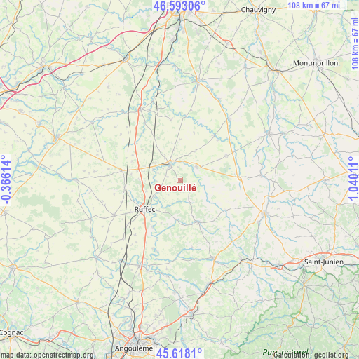
Genouillé GPS coordinates[2]
46° 6' 27.864" North, 0° 20' 13.164" East
| Map corner | latitude | longitude |
|---|---|---|
| Upper-left | 46.59306°, | -0.36614° |
| Center: | 46.10774°, | 0.33699° |
| Lower-right: | 45.6181°, | 1.04011° |
| Map W x H: | 108.4×108.4 km | = 67.4×67.4mi |
| max Lat: | 51.07786° ⇑65% North |
| Genouillé: | 46.10774° |
| min Lat: | ⇓35% South 41.3874° |
| min Long | Genouillé | max Long |
| -5.08615° | 0.33699° | 9.52242° |
| W 25%⇐ | ⇒75% E |
Elevation
Elevation of Genouillé is 151 m = 495 ft, and this is 42.7 m = 140 ft below average elevation for this country.
| Max E: |
2333 m = 7654 ft | 44.7% |
| Avg. | 193.7 m = 635 ft | |
| Genouillé | 151 m = 495 ft | |
Min E: |
-1 m = -3 ft | 55.3% |
See also: France elevation on elevation.city.
Geographical zone
Genouillé is located in North temperate zone (between Tropic of Cancer and the Arctic Circle). Distance of this North polar circle is 2274.5 km =1413.3 mi to North.| Distance of | km | miles | from Genouillé |
|---|---|---|---|
| North Pole | 4880.4 | 3032.5 | to North |
| Arctic Circle | 2274.5 | 1413.3 | to North |
| Tropic Cancer | 2520.8 | 1566.4 | to South |
| Equator | 5126.7 | 3185.6 | to South |


Nearby cities:
15 places around Genouillé: (largest is in red/bold)
• Alloue
16.1 km =10 mi,  120°
120°
• Blanzay
12.2 km =7.6 mi,  328°
328°
• Champagne-Mouton
14.2 km =8.8 mi,  156°
156°
• Charroux
6.5 km =4 mi,  51°
51°
• Chaunay
17.3 km =10.7 mi,  309°
309°
• Civray
5.5 km =3.4 mi,  324°
324°
• La Faye
17.7 km =11 mi,  236°
236°
• Limalonges
13.2 km =8.2 mi,  280°
280°
• Mauprévoir
15.7 km =9.8 mi,  62°
62°
• Nanteuil-en-Vallée
11.9 km =7.4 mi,  185°
185°
• Payroux
16.3 km =10.1 mi,  43°
43°
• Ruffec
13.8 km =8.6 mi,  230°
230°
• Savigné
5.8 km =3.6 mi,  347°
347°
• Taizé-Aizie
9.1 km =5.7 mi, 238°
• Verteuil-sur-Charente
16.3 km =10.1 mi,  210°
210°
Sources, notices
• [Note1] Compared only with cities in France existing in our database
• [Src1] Map data: © OpenStreetMap contributors (CC-BY-SA)
• [Src2] Other city data from geonames.org with taken over terms of usage.
• [Src3] Geographical zone / Annual Mean Temperature by Robert A. Rohde @ Wikipedia
