Faramans geodata
Faramans (Auvergne-Rhône-Alpes) is a populated place; located in France in Europe/Paris (GMT+2) time zone. With population of 800 people, there are 10613 cities with bigger population in this country. Compared to other cities in France, 75.4% of cities are located further ↑North; 79.4% of cities are located further ←West and 86.4% of cities have lower elevation than Faramans. Note1
Administrative division(s):
- Level 1: Auvergne-Rhône-Alpes
- Level 2: Département de l'Isère
- Level 3: Arrondissement de Vienne
- Level 4: Faramans


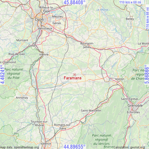
Faramans GPS coordinates[2]
45° 23' 32.892" North, 5° 9' 55.944" East
| Map corner | latitude | longitude |
|---|---|---|
| Upper-left | 45.88408°, | 4.46241° |
| Center: | 45.39247°, | 5.16554° |
| Lower-right: | 44.89655°, | 5.86866° |
| Map W x H: | 109.8×109.8 km | = 68.2×68.2mi |
| max Lat: | 51.07786° ⇑75.4% North |
| Faramans: | 45.39247° |
| min Lat: | ⇓24.6% South 41.3874° |
| min Long | Faramans | max Long |
| -5.08615° | 5.16554° | 9.52242° |
| W 79.4%⇐ | ⇒20.6% E |
Elevation
Elevation of Faramans is 365 m = 1198 ft, and this is 171.3 m = 562 ft above average elevation for this country.
| Max E: |
2333 m = 7654 ft | 13.6% |
| Faramans | 365 m 1198 ft | |
| Avg. | 193.7 m = 635 ft | |
Min E: |
-1 m = -3 ft | 86.4% |
See also: France elevation on elevation.city.
Geographical zone
Faramans is located in North temperate zone (between Tropic of Cancer and the Arctic Circle). Distance of this North polar circle is 2354 km =1462.7 mi to North.| Distance of | km | miles | from Faramans |
|---|---|---|---|
| North Pole | 4959.9 | 3081.9 | to North |
| Arctic Circle | 2354 | 1462.7 | to North |
| Tropic Cancer | 2441.3 | 1517 | to South |
| Equator | 5047.2 | 3136.2 | to South |


Nearby cities:
15 places around Faramans: (largest is in red/bold)
• Beaurepaire
11 km =6.8 mi,  235°
235°
• Commelle
6.2 km =3.9 mi,  49°
49°
• Gillonnay
10 km =6.2 mi,  89°
89°
• La Côte-Saint-André
7.3 km =4.5 mi, 88°
• Marcilloles
5.7 km =3.5 mi,  166°
166°
• Pajay
4.1 km =2.5 mi,  215°
215°
• Pisieu
8.1 km =5 mi,  265°
265°
• Pommier-de-Beaurepaire
3.8 km =2.4 mi,  279°
279°
• Primarette
10.7 km =6.6 mi, 275°
• Revel
10.3 km =6.4 mi,  263°
263°
• Saint-Siméon-de-Bressieux
9.9 km =6.2 mi,  127°
127°
• Sardieu
4.5 km =2.8 mi, 126°
• Thodure
8.4 km =5.2 mi,  178°
178°
• Villeneuve-de-Marc
10.7 km =6.6 mi,  332°
332°
• Viriville
9 km =5.6 mi,  160°
160°
Sources, notices
• [Note1] Compared only with cities in France existing in our database
• [Src1] Map data: © OpenStreetMap contributors (CC-BY-SA)
• [Src2] Other city data from geonames.org with taken over terms of usage.
• [Src3] Geographical zone / Annual Mean Temperature by Robert A. Rohde @ Wikipedia
