Lens-Lestang geodata
Lens-Lestang (Auvergne-Rhône-Alpes) is a populated place; located in France in Europe/Paris (GMT+2) time zone. With population of 716 people, there are 11580 cities with bigger population in this country. Compared to other cities in France, 76.4% of cities are located further ↑North; 78.1% of cities are located further ←West and 83.7% of cities have lower elevation than Lens-Lestang. Note1
Administrative division(s):
- Level 1: Auvergne-Rhône-Alpes
- Level 2: Département de la Drôme
- Level 3: Arrondissement de Valence
- Level 4: Lens-Lestang


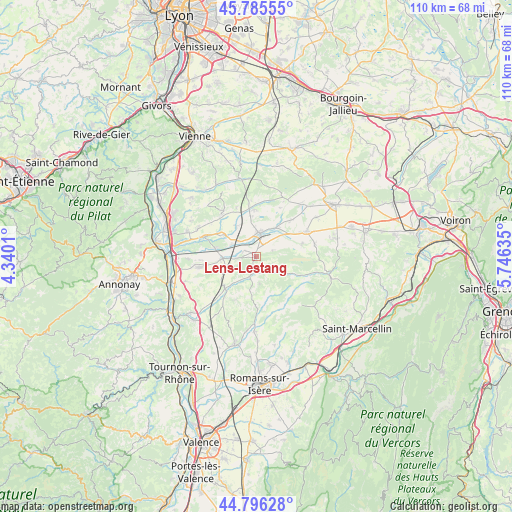
Lens-Lestang GPS coordinates[2]
45° 17' 35.052" North, 5° 2' 35.628" East
| Map corner | latitude | longitude |
|---|---|---|
| Upper-left | 45.78555°, | 4.3401° |
| Center: | 45.29307°, | 5.04323° |
| Lower-right: | 44.79628°, | 5.74635° |
| Map W x H: | 110×110 km | = 68.4×68.4mi |
| max Lat: | 51.07786° ⇑76.4% North |
| Lens-Lestang: | 45.29307° |
| min Lat: | ⇓23.6% South 41.3874° |
| min Long | Lens-Lestang | max Long |
| -5.08615° | 5.04323° | 9.52242° |
| W 78.1%⇐ | ⇒21.9% E |
Elevation
Elevation of Lens-Lestang is 331 m = 1086 ft, and this is 137.3 m = 450 ft above average elevation for this country.
| Max E: |
2333 m = 7654 ft | 16.3% |
| Lens-Lestang | 331 m 1086 ft | |
| Avg. | 193.7 m = 635 ft | |
Min E: |
-1 m = -3 ft | 83.7% |
See also: France elevation on elevation.city.
Geographical zone
Lens-Lestang is located in North temperate zone (between Tropic of Cancer and the Arctic Circle). Distance of this North polar circle is 2365.1 km =1469.6 mi to North.| Distance of | km | miles | from Lens-Lestang |
|---|---|---|---|
| North Pole | 4970.9 | 3088.8 | to North |
| Arctic Circle | 2365.1 | 1469.6 | to North |
| Tropic Cancer | 2430.2 | 1510.1 | to South |
| Equator | 5036.1 | 3129.3 | to South |


Nearby cities:
15 places around Lens-Lestang: (largest is in red/bold)
• Beaurepaire
4.9 km =3 mi,  5°
5°
• Châteauneuf-de-Galaure
9.7 km =6 mi,  223°
223°
• Hauterives
4.6 km =2.9 mi,  204°
204°
• Jarcieu
9 km =5.6 mi,  300°
300°
• Lapeyrouse-Mornay
5.1 km =3.2 mi,  312°
312°
• Le Grand-Serre
5.5 km =3.4 mi,  118°
118°
• Manthes
2.8 km =1.7 mi, 296°
• Marcollin
3.3 km =2.1 mi,  65°
65°
• Moras-en-Valloire
3.4 km =2.1 mi,  266°
266°
• Pact
7.8 km =4.8 mi,  327°
327°
• Pajay
10.5 km =6.5 mi,  42°
42°
• Revel
9.9 km =6.2 mi,  355°
355°
• Saint-Sorlin-en-Valloire
7.4 km =4.6 mi, 265°
• Thodure
10.2 km =6.3 mi, 74°
• Épinouze
9.1 km =5.7 mi,  281°
281°
Sources, notices
• [Note1] Compared only with cities in France existing in our database
• [Src1] Map data: © OpenStreetMap contributors (CC-BY-SA)
• [Src2] Other city data from geonames.org with taken over terms of usage.
• [Src3] Geographical zone / Annual Mean Temperature by Robert A. Rohde @ Wikipedia
