Pageas geodata
Pageas (Nouvelle-Aquitaine) is a populated place; located in France in Europe/Paris (GMT+2) time zone. With population of 620 people, there are 12983 cities with bigger population in this country. Compared to other cities in France, 71.3% of cities are located further ↑North; 68.8% of cities are located further →East and 86.4% of cities have lower elevation than Pageas. Note1
Administrative division(s):
- Level 1: Nouvelle-Aquitaine
- Level 2: Haute-Vienne
- Level 3: Arrondissement de Limoges
- Level 4: Pageas


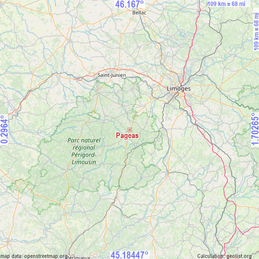
Pageas GPS coordinates[2]
45° 40' 40.404" North, 0° 59' 58.308" East
| Map corner | latitude | longitude |
|---|---|---|
| Upper-left | 46.167°, | 0.2964° |
| Center: | 45.67789°, | 0.99953° |
| Lower-right: | 45.18447°, | 1.70265° |
| Map W x H: | 109.2×109.2 km | = 67.9×67.9mi |
| max Lat: | 51.07786° ⇑71.3% North |
| Pageas: | 45.67789° |
| min Lat: | ⇓28.7% South 41.3874° |
| min Long | Pageas | max Long |
| -5.08615° | 0.99953° | 9.52242° |
| W 31.2%⇐ | ⇒68.8% E |
Elevation
Elevation of Pageas is 366 m = 1201 ft, and this is 172.3 m = 565 ft above average elevation for this country.
| Max E: |
2333 m = 7654 ft | 13.6% |
| Pageas | 366 m 1201 ft | |
| Avg. | 193.7 m = 635 ft | |
Min E: |
-1 m = -3 ft | 86.4% |
See also: France elevation on elevation.city.
Geographical zone
Pageas is located in North temperate zone (between Tropic of Cancer and the Arctic Circle). Distance of this North polar circle is 2322.3 km =1443 mi to North.| Distance of | km | miles | from Pageas |
|---|---|---|---|
| North Pole | 4928.2 | 3062.2 | to North |
| Arctic Circle | 2322.3 | 1443 | to North |
| Tropic Cancer | 2473 | 1536.7 | to South |
| Equator | 5078.9 | 3155.9 | to South |


Nearby cities:
15 places around Pageas: (largest is in red/bold)
• Burgnac
12.9 km =8 mi,  65°
65°
• Bussière-Galant
6.4 km =4 mi,  153°
153°
• Champagnac-la-Rivière
7.6 km =4.7 mi,  298°
298°
• Champsac
4.3 km =2.7 mi,  309°
309°
• Châlus
3 km =1.9 mi,  210°
210°
• Cussac
12.1 km =7.5 mi,  285°
285°
• Dournazac
8.7 km =5.4 mi,  227°
227°
• Flavignac
7.8 km =4.8 mi, 67°
• Ladignac-le-Long
13.8 km =8.6 mi,  140°
140°
• Les Cars
5.7 km =3.5 mi,  86°
86°
• Oradour-sur-Vayres
11.9 km =7.4 mi, 300°
• Saint-Hilaire-les-Places
12.9 km =8 mi,  106°
106°
• Saint-Laurent-sur-Gorre
10.7 km =6.6 mi,  342°
342°
• Saint-Martin-le-Vieux
11.9 km =7.4 mi,  51°
51°
• Séreilhac
12 km =7.5 mi,  32°
32°
Sources, notices
• [Note1] Compared only with cities in France existing in our database
• [Src1] Map data: © OpenStreetMap contributors (CC-BY-SA)
• [Src2] Other city data from geonames.org with taken over terms of usage.
• [Src3] Geographical zone / Annual Mean Temperature by Robert A. Rohde @ Wikipedia
