Champagnac-la-Rivière geodata
Champagnac-la-Rivière (Nouvelle-Aquitaine) is a populated place; located in France in Europe/Paris (GMT+2) time zone. With population of 589 people, there are 13496 cities with bigger population in this country. Compared to other cities in France, 70.7% of cities are located further ↑North; 69.6% of cities are located further →East and 83.6% of cities have lower elevation than Champagnac-la-Rivière. Note1
Administrative division(s):
- Level 1: Nouvelle-Aquitaine
- Level 2: Haute-Vienne
- Level 3: Arrondissement de Rochechouart
- Level 4: Champagnac-la-Rivière
Current local time in Champagnac-la-Rivière:
12:03 PM, SaturdayDifference from your time zone: hours


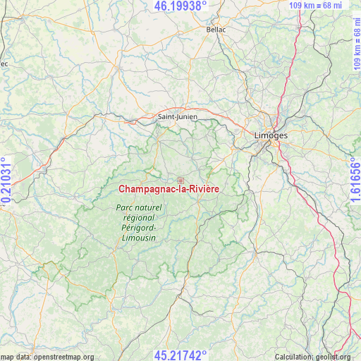
Champagnac-la-Rivière GPS coordinates[2]
45° 42' 38.016" North, 0° 54' 48.348" East
| Map corner | latitude | longitude |
|---|---|---|
| Upper-left | 46.19938°, | 0.21031° |
| Center: | 45.71056°, | 0.91343° |
| Lower-right: | 45.21742°, | 1.61656° |
| Map W x H: | 109.2×109.2 km | = 67.9×67.9mi |
| max Lat: | 51.07786° ⇑70.7% North |
| Champagnac-la-Rivière: | 45.71056° |
| min Lat: | ⇓29.3% South 41.3874° |
| min Long | Champagnac-la-R | max Long |
| -5.08615° | 0.91343° | 9.52242° |
| W 30.4%⇐ | ⇒69.6% E |
Elevation
Elevation of Champagnac-la-Rivière is 330 m = 1083 ft, and this is 136.3 m = 447 ft above average elevation for this country.
| Max E: |
2333 m = 7654 ft | 16.4% |
| Champagnac-la-Rivière | 330 m 1083 ft | |
| Avg. | 193.7 m = 635 ft | |
Min E: |
-1 m = -3 ft | 83.6% |
See also: France elevation on elevation.city.
Geographical zone
Champagnac-la-Rivière is located in North temperate zone (between Tropic of Cancer and the Arctic Circle). Distance of this North polar circle is 2318.6 km =1440.7 mi to North.| Distance of | km | miles | from Champagnac-la-Rivière |
|---|---|---|---|
| North Pole | 4924.5 | 3059.9 | to North |
| Arctic Circle | 2318.6 | 1440.7 | to North |
| Tropic Cancer | 2476.6 | 1538.9 | to South |
| Equator | 5082.5 | 3158.1 | to South |


Nearby cities:
15 places around Champagnac-la-Rivière: (largest is in red/bold)
• Bussière-Galant
13.3 km =8.3 mi,  134°
134°
• Champsac
3.5 km =2.2 mi,  104°
104°
• Châlus
8.1 km =5 mi,  139°
139°
• Cussac
5 km =3.1 mi,  265°
265°
• Dournazac
9.5 km =5.9 mi,  178°
178°
• Flavignac
13.9 km =8.6 mi,  92°
92°
• Les Cars
12.8 km =8 mi,  105°
105°
• Marval
12.9 km =8 mi,  224°
224°
• Oradour-sur-Vayres
4.3 km =2.7 mi,  303°
303°
• Pageas
7.6 km =4.7 mi,  118°
118°
• Saint-Auvent
10.6 km =6.6 mi,  7°
7°
• Saint-Cyr
10.5 km =6.5 mi,  19°
19°
• Saint-Laurent-sur-Gorre
7.4 km =4.6 mi,  27°
27°
• Saint-Mathieu
12 km =7.5 mi, 267°
• Vayres
9.6 km =6 mi, 304°
Sources, notices
• [Note1] Compared only with cities in France existing in our database
• [Src1] Map data: © OpenStreetMap contributors (CC-BY-SA)
• [Src2] Other city data from geonames.org with taken over terms of usage.
• [Src3] Geographical zone / Annual Mean Temperature by Robert A. Rohde @ Wikipedia
