Ouveillan geodata
Ouveillan (Occitanie) is a populated place; located in France in Europe/Paris (GMT+2) time zone. With population of 2,041 people, there are 4704 cities with bigger population in this country. Compared to other cities in France, 95.9% of cities are located further ↑North; 57.4% of cities are located further ←West and 86.7% of cities have higher elevation than Ouveillan. Note1
Administrative division(s):
- Level 1: Occitanie
- Level 2: Département de l'Aude
- Level 3: Arrondissement de Narbonne
- Level 4: Ouveillan


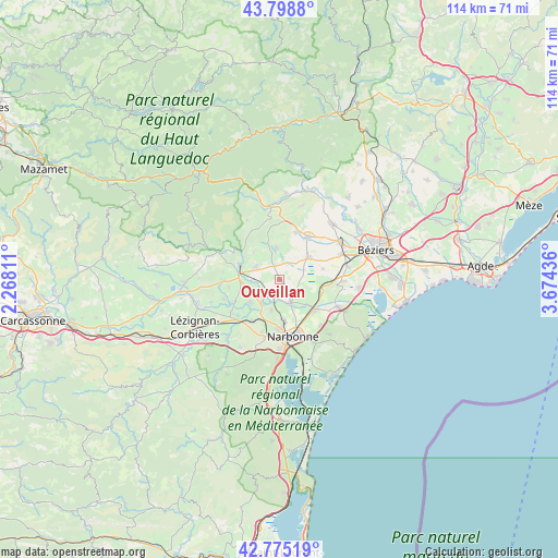
Ouveillan GPS coordinates[2]
43° 17' 20.94" North, 2° 58' 16.464" East
| Map corner | latitude | longitude |
|---|---|---|
| Upper-left | 43.7988°, | 2.26811° |
| Center: | 43.28915°, | 2.97124° |
| Lower-right: | 42.77519°, | 3.67436° |
| Map W x H: | 113.8×113.8 km | = 70.7×70.7mi |
| max Lat: | 51.07786° ⇑95.9% North |
| Ouveillan: | 43.28915° |
| min Lat: | ⇓4.1% South 41.3874° |
| min Long | Ouveillan | max Long |
| -5.08615° | 2.97124° | 9.52242° |
| W 57.4%⇐ | ⇒42.6% E |
Elevation
Elevation of Ouveillan is 38 m = 125 ft, and this is 155.7 m = 511 ft below average elevation for this country.
| Max E: |
2333 m = 7654 ft | 86.7% |
| Avg. | 193.7 m = 635 ft | |
| Ouveillan | 38 m = 125 ft | |
Min E: |
-1 m = -3 ft | 13.3% |
See also: France elevation on elevation.city.
Geographical zone
Ouveillan is located in North temperate zone (between Tropic of Cancer and the Arctic Circle). Distance of this Northern Tropic circle is 2207.4 km =1371.6 mi to South.| Distance of | km | miles | from Ouveillan |
|---|---|---|---|
| North Pole | 5193.8 | 3227.3 | to North |
| Arctic Circle | 2587.9 | 1608 | to North |
| Tropic Cancer | 2207.4 | 1371.6 | to South |
| Equator | 4813.3 | 2990.8 | to South |


Nearby cities:
15 places around Ouveillan: (largest is in red/bold)
• Argeliers
5.5 km =3.4 mi,  297°
297°
• Bize-Minervois
8.6 km =5.3 mi,  290°
290°
• Capestang
7.3 km =4.5 mi,  53°
53°
• Coursan
9.3 km =5.8 mi,  131°
131°
• Creissan
10.1 km =6.3 mi,  18°
18°
• Cruzy
7.8 km =4.8 mi,  341°
341°
• Ginestas
8.5 km =5.3 mi,  252°
252°
• Marcorignan
8 km =5 mi,  209°
209°
• Mirepeisset
5.9 km =3.7 mi,  263°
263°
• Moussan
6.7 km =4.2 mi,  194°
194°
• Névian
10.2 km =6.3 mi, 212°
• Quarante
6.5 km =4 mi,  353°
353°
• Saint-Marcel-sur-Aude
5.3 km =3.3 mi,  215°
215°
• Saint-Nazaire-d’Aude
7.9 km =4.9 mi,  231°
231°
• Ventenac-en-Minervois
9.5 km =5.9 mi,  242°
242°
Sources, notices
• [Note1] Compared only with cities in France existing in our database
• [Src1] Map data: © OpenStreetMap contributors (CC-BY-SA)
• [Src2] Other city data from geonames.org with taken over terms of usage.
• [Src3] Geographical zone / Annual Mean Temperature by Robert A. Rohde @ Wikipedia
