Névian geodata
Névian (Occitanie) is a populated place; located in France in Europe/Paris (GMT+2) time zone. With population of 1,160 people, there are 7765 cities with bigger population in this country. Compared to other cities in France, 97% of cities are located further ↑North; 56.4% of cities are located further ←West and 90.3% of cities have higher elevation than Névian. Note1
Administrative division(s):
- Level 1: Occitanie
- Level 2: Département de l'Aude
- Level 3: Arrondissement de Narbonne
- Level 4: Névian


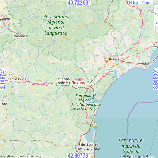
Névian GPS coordinates[2]
43° 12' 44.568" North, 2° 54' 10.296" East
| Map corner | latitude | longitude |
|---|---|---|
| Upper-left | 43.72268°, | 2.19974° |
| Center: | 43.21238°, | 2.90286° |
| Lower-right: | 42.69778°, | 3.60599° |
| Map W x H: | 114×114 km | = 70.8×70.8mi |
| max Lat: | 51.07786° ⇑97% North |
| Névian: | 43.21238° |
| min Lat: | ⇓3% South 41.3874° |
| min Long | Névian | max Long |
| -5.08615° | 2.90286° | 9.52242° |
| W 56.4%⇐ | ⇒43.6% E |
Elevation
Elevation of Névian is 29 m = 95 ft, and this is 164.7 m = 540 ft below average elevation for this country.
| Max E: |
2333 m = 7654 ft | 90.3% |
| Avg. | 193.7 m = 635 ft | |
| Névian | 29 m = 95 ft | |
Min E: |
-1 m = -3 ft | 9.7% |
See also: France elevation on elevation.city.
Geographical zone
Névian is located in North temperate zone (between Tropic of Cancer and the Arctic Circle). Distance of this Northern Tropic circle is 2198.8 km =1366.3 mi to South.| Distance of | km | miles | from Névian |
|---|---|---|---|
| North Pole | 5202.3 | 3232.6 | to North |
| Arctic Circle | 2596.4 | 1613.3 | to North |
| Tropic Cancer | 2198.8 | 1366.3 | to South |
| Equator | 4804.8 | 2985.6 | to South |


Nearby cities:
15 places around Névian: (largest is in red/bold)
• Bizanet
6 km =3.7 mi,  206°
206°
• Canet
4.8 km =3 mi,  290°
290°
• Ginestas
6.6 km =4.1 mi,  336°
336°
• Luc-sur-Orbieu
10.3 km =6.4 mi,  247°
247°
• Marcorignan
2.2 km =1.4 mi,  46°
46°
• Mirepeisset
7.9 km =4.9 mi,  357°
357°
• Montredon-des-Corbières
4.1 km =2.5 mi,  142°
142°
• Moussan
4.3 km =2.7 mi,  61°
61°
• Narbonne
8.6 km =5.3 mi,  111°
111°
• Ornaisons
6.4 km =4 mi,  236°
236°
• Ouveillan
10.2 km =6.3 mi,  32°
32°
• Saint-Marcel-sur-Aude
4.9 km =3 mi, 30°
• Saint-Nazaire-d’Aude
3.7 km =2.3 mi,  349°
349°
• Sainte-Valière
8.4 km =5.2 mi,  323°
323°
• Ventenac-en-Minervois
5.1 km =3.2 mi, 324°
Sources, notices
• [Note1] Compared only with cities in France existing in our database
• [Src1] Map data: © OpenStreetMap contributors (CC-BY-SA)
• [Src2] Other city data from geonames.org with taken over terms of usage.
• [Src3] Geographical zone / Annual Mean Temperature by Robert A. Rohde @ Wikipedia
