Quarante geodata
Quarante (Occitanie) is a populated place; located in France in Europe/Paris (GMT+2) time zone. With population of 1,490 people, there are 6229 cities with bigger population in this country. Compared to other cities in France, 94.9% of cities are located further ↑North; 57.3% of cities are located further ←West and 56.5% of cities have higher elevation than Quarante. Note1
Administrative division(s):
- Level 1: Occitanie
- Level 2: Département de l'Hérault
- Level 3: Arrondissement de Béziers
- Level 4: Quarante


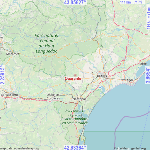
Quarante GPS coordinates[2]
43° 20' 49.596" North, 2° 57' 44.208" East
| Map corner | latitude | longitude |
|---|---|---|
| Upper-left | 43.85627°, | 2.25915° |
| Center: | 43.34711°, | 2.96228° |
| Lower-right: | 42.83364°, | 3.6654° |
| Map W x H: | 113.7×113.7 km | = 70.6×70.6mi |
| max Lat: | 51.07786° ⇑94.9% North |
| Quarante: | 43.34711° |
| min Lat: | ⇓5.1% South 41.3874° |
| min Long | Quarante | max Long |
| -5.08615° | 2.96228° | 9.52242° |
| W 57.3%⇐ | ⇒42.7% E |
Elevation
Elevation of Quarante is 112 m = 367 ft, and this is 81.7 m = 268 ft below average elevation for this country.
| Max E: |
2333 m = 7654 ft | 56.5% |
| Avg. | 193.7 m = 635 ft | |
| Quarante | 112 m = 367 ft | |
Min E: |
-1 m = -3 ft | 43.5% |
See also: France elevation on elevation.city.
Geographical zone
Quarante is located in North temperate zone (between Tropic of Cancer and the Arctic Circle). Distance of this Northern Tropic circle is 2213.8 km =1375.6 mi to South.| Distance of | km | miles | from Quarante |
|---|---|---|---|
| North Pole | 5187.3 | 3223.2 | to North |
| Arctic Circle | 2581.4 | 1604 | to North |
| Tropic Cancer | 2213.8 | 1375.6 | to South |
| Equator | 4819.7 | 2994.8 | to South |


Nearby cities:
15 places around Quarante: (largest is in red/bold)
• Argeliers
5.7 km =3.5 mi,  227°
227°
• Bize-Minervois
8.1 km =5 mi,  245°
245°
• Capestang
7 km =4.3 mi,  107°
107°
• Cazouls-lès-Béziers
12.3 km =7.6 mi,  65°
65°
• Creissan
5.1 km =3.2 mi,  52°
52°
• Cruzy
2 km =1.2 mi,  298°
298°
• Ginestas
11.7 km =7.3 mi,  219°
219°
• Maureilhan
12.5 km =7.8 mi,  88°
88°
• Mirepeisset
8.7 km =5.4 mi, 216°
• Ouveillan
6.5 km =4 mi,  173°
173°
• Puisserguier
6.7 km =4.2 mi, 70°
• Saint-Chinian
8.5 km =5.3 mi,  351°
351°
• Saint-Marcel-sur-Aude
11 km =6.8 mi,  192°
192°
• Saint-Nazaire-d’Aude
12.6 km =7.8 mi,  205°
205°
• Sainte-Valière
12.8 km =8 mi, 229°
Sources, notices
• [Note1] Compared only with cities in France existing in our database
• [Src1] Map data: © OpenStreetMap contributors (CC-BY-SA)
• [Src2] Other city data from geonames.org with taken over terms of usage.
• [Src3] Geographical zone / Annual Mean Temperature by Robert A. Rohde @ Wikipedia
