Creissan geodata
Creissan (Occitanie) is a populated place; located in France in Europe/Paris (GMT+2) time zone. With population of 1,103 people, there are 8112 cities with bigger population in this country. Compared to other cities in France, 94.5% of cities are located further ↑North; 58% of cities are located further ←West and 57.6% of cities have higher elevation than Creissan. Note1
Administrative division(s):
- Level 1: Occitanie
- Level 2: Département de l'Hérault
- Level 3: Arrondissement de Béziers
- Level 4: Creissan


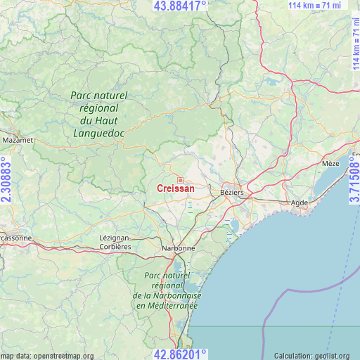
Creissan GPS coordinates[2]
43° 22' 30.864" North, 3° 0' 43.056" East
| Map corner | latitude | longitude |
|---|---|---|
| Upper-left | 43.88417°, | 2.30883° |
| Center: | 43.37524°, | 3.01196° |
| Lower-right: | 42.86201°, | 3.71508° |
| Map W x H: | 113.7×113.7 km | = 70.6×70.6mi |
| max Lat: | 51.07786° ⇑94.5% North |
| Creissan: | 43.37524° |
| min Lat: | ⇓5.5% South 41.3874° |
| min Long | Creissan | max Long |
| -5.08615° | 3.01196° | 9.52242° |
| W 58%⇐ | ⇒42% E |
Elevation
Elevation of Creissan is 109 m = 358 ft, and this is 84.7 m = 278 ft below average elevation for this country.
| Max E: |
2333 m = 7654 ft | 57.6% |
| Avg. | 193.7 m = 635 ft | |
| Creissan | 109 m = 358 ft | |
Min E: |
-1 m = -3 ft | 42.4% |
See also: France elevation on elevation.city.
Geographical zone
Creissan is located in North temperate zone (between Tropic of Cancer and the Arctic Circle). Distance of this Northern Tropic circle is 2217 km =1377.6 mi to South.| Distance of | km | miles | from Creissan |
|---|---|---|---|
| North Pole | 5184.2 | 3221.3 | to North |
| Arctic Circle | 2578.3 | 1602.1 | to North |
| Tropic Cancer | 2217 | 1377.6 | to South |
| Equator | 4822.9 | 2996.8 | to South |


Nearby cities:
15 places around Creissan: (largest is in red/bold)
• Argeliers
10.8 km =6.7 mi,  229°
229°
• Capestang
5.9 km =3.7 mi,  153°
153°
• Causses-et-Veyran
12.5 km =7.8 mi,  28°
28°
• Cazouls-lès-Béziers
7.4 km =4.6 mi,  75°
75°
• Cessenon-sur-Orb
8.9 km =5.5 mi,  21°
21°
• Colombiers
12.3 km =7.6 mi,  123°
123°
• Cruzy
6.1 km =3.8 mi,  248°
248°
• Maraussan
11.7 km =7.3 mi,  93°
93°
• Maureilhan
8.9 km =5.5 mi,  108°
108°
• Montady
10.3 km =6.4 mi, 115°
• Murviel-lès-Béziers
11.7 km =7.3 mi,  56°
56°
• Ouveillan
10.1 km =6.3 mi,  198°
198°
• Puisserguier
2.5 km =1.6 mi, 110°
• Quarante
5.1 km =3.2 mi, 232°
• Saint-Chinian
7.4 km =4.6 mi,  314°
314°
Sources, notices
• [Note1] Compared only with cities in France existing in our database
• [Src1] Map data: © OpenStreetMap contributors (CC-BY-SA)
• [Src2] Other city data from geonames.org with taken over terms of usage.
• [Src3] Geographical zone / Annual Mean Temperature by Robert A. Rohde @ Wikipedia
