Ouarville geodata
Ouarville (Centre) is a populated place; located in France in Europe/Paris (GMT+2) time zone. With population of 567 people, there are 13878 cities with bigger population in this country. Compared to other cities in France, 65.6% of cities are located further ↓South; 59.6% of cities are located further →East and 55% of cities have lower elevation than Ouarville. Note1
Administrative division(s):
- Level 1: Centre
- Level 2: Département d'Eure-et-Loir
- Level 3: Arrondissement de Chartres
- Level 4: Ouarville


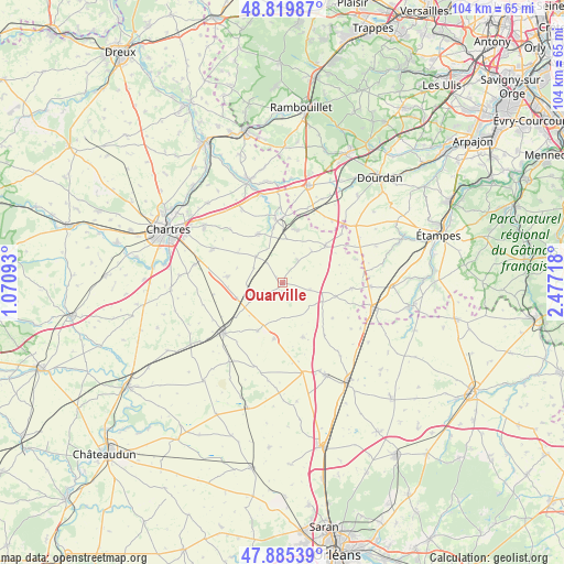
Ouarville GPS coordinates[2]
48° 21' 17.172" North, 1° 46' 26.616" East
| Map corner | latitude | longitude |
|---|---|---|
| Upper-left | 48.81987°, | 1.07093° |
| Center: | 48.35477°, | 1.77406° |
| Lower-right: | 47.88539°, | 2.47718° |
| Map W x H: | 103.9×103.9 km | = 64.6×64.6mi |
| max Lat: | 51.07786° ⇑34.4% North |
| Ouarville: | 48.35477° |
| min Lat: | ⇓65.6% South 41.3874° |
| min Long | Ouarville | max Long |
| -5.08615° | 1.77406° | 9.52242° |
| W 40.4%⇐ | ⇒59.6% E |
Elevation
Elevation of Ouarville is 150 m = 492 ft, and this is 43.7 m = 143 ft below average elevation for this country.
| Max E: |
2333 m = 7654 ft | 45% |
| Avg. | 193.7 m = 635 ft | |
| Ouarville | 150 m = 492 ft | |
Min E: |
-1 m = -3 ft | 55% |
See also: France elevation on elevation.city.
Geographical zone
Ouarville is located in North temperate zone (between Tropic of Cancer and the Arctic Circle). Distance of this North polar circle is 2024.6 km =1258 mi to North.| Distance of | km | miles | from Ouarville |
|---|---|---|---|
| North Pole | 4630.5 | 2877.3 | to North |
| Arctic Circle | 2024.6 | 1258 | to North |
| Tropic Cancer | 2770.6 | 1721.6 | to South |
| Equator | 5376.5 | 3340.8 | to South |


Nearby cities:
15 places around Ouarville: (largest is in red/bold)
• Angerville
17.3 km =10.7 mi,  105°
105°
• Aunay-sous-Auneau
10 km =6.2 mi,  15°
15°
• Auneau
12.1 km =7.5 mi,  359°
359°
• Berchères-les-Pierres
16.6 km =10.3 mi,  281°
281°
• Boisville-la-Saint-Père
6.7 km =4.2 mi,  244°
244°
• Béville-le-Comte
10.1 km =6.3 mi,  333°
333°
• Denonville
4.9 km =3 mi,  35°
35°
• Francourville
10.2 km =6.3 mi,  304°
304°
• Le Gué-de-Longroi
16.8 km =10.4 mi,  346°
346°
• Prunay-le-Gillon
10.3 km =6.4 mi, 275°
• Pussay
16.1 km =10 mi,  92°
92°
• Saint-Escobille
16.7 km =10.4 mi,  58°
58°
• Sainville
10.3 km =6.4 mi,  49°
49°
• Sours
14.3 km =8.9 mi, 295°
• Voves
14.4 km =8.9 mi,  229°
229°
Sources, notices
• [Note1] Compared only with cities in France existing in our database
• [Src1] Map data: © OpenStreetMap contributors (CC-BY-SA)
• [Src2] Other city data from geonames.org with taken over terms of usage.
• [Src3] Geographical zone / Annual Mean Temperature by Robert A. Rohde @ Wikipedia
