Denonville geodata
Denonville (Centre) is a populated place; located in France in Europe/Paris (GMT+2) time zone. With population of 824 people, there are 10351 cities with bigger population in this country. Compared to other cities in France, 66.2% of cities are located further ↓South; 59.3% of cities are located further →East and 55% of cities have lower elevation than Denonville. Note1
Administrative division(s):
- Level 1: Centre
- Level 2: Département d'Eure-et-Loir
- Level 3: Arrondissement de Chartres
- Level 4: Denonville


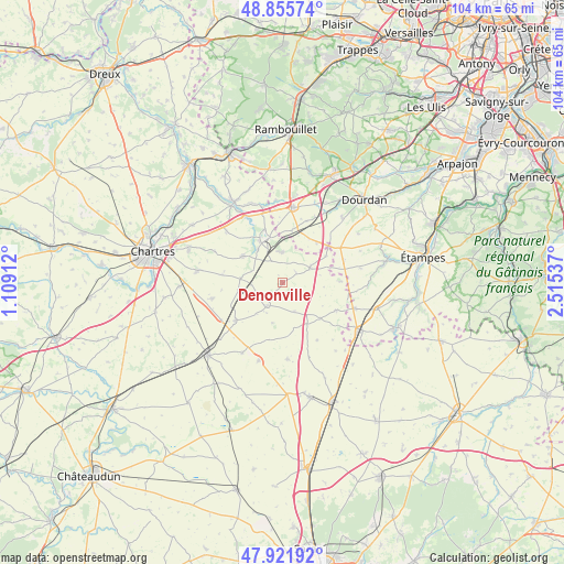
Denonville GPS coordinates[2]
48° 23' 27.492" North, 1° 48' 44.064" East
| Map corner | latitude | longitude |
|---|---|---|
| Upper-left | 48.85574°, | 1.10912° |
| Center: | 48.39097°, | 1.81224° |
| Lower-right: | 47.92192°, | 2.51537° |
| Map W x H: | 103.8×103.8 km | = 64.5×64.5mi |
| max Lat: | 51.07786° ⇑33.8% North |
| Denonville: | 48.39097° |
| min Lat: | ⇓66.2% South 41.3874° |
| min Long | Denonville | max Long |
| -5.08615° | 1.81224° | 9.52242° |
| W 40.7%⇐ | ⇒59.3% E |
Elevation
Elevation of Denonville is 150 m = 492 ft, and this is 43.7 m = 143 ft below average elevation for this country.
| Max E: |
2333 m = 7654 ft | 45% |
| Avg. | 193.7 m = 635 ft | |
| Denonville | 150 m = 492 ft | |
Min E: |
-1 m = -3 ft | 55% |
See also: France elevation on elevation.city.
Geographical zone
Denonville is located in North temperate zone (between Tropic of Cancer and the Arctic Circle). Distance of this North polar circle is 2020.6 km =1255.5 mi to North.| Distance of | km | miles | from Denonville |
|---|---|---|---|
| North Pole | 4626.5 | 2874.8 | to North |
| Arctic Circle | 2020.6 | 1255.5 | to North |
| Tropic Cancer | 2774.7 | 1724.1 | to South |
| Equator | 5380.6 | 3343.3 | to South |


Nearby cities:
15 places around Denonville: (largest is in red/bold)
• Ablis
14.1 km =8.8 mi,  7°
7°
• Aunay-sous-Auneau
5.6 km =3.5 mi,  359°
359°
• Auneau
8.6 km =5.3 mi,  340°
340°
• Boisville-la-Saint-Père
11.2 km =7 mi,  231°
231°
• Béville-le-Comte
8.8 km =5.5 mi,  304°
304°
• Francourville
11.4 km =7.1 mi,  278°
278°
• Le Gué-de-Longroi
14 km =8.7 mi,  330°
330°
• Ouarville
4.9 km =3 mi,  215°
215°
• Prunay-le-Gillon
13.4 km =8.3 mi,  257°
257°
• Pussay
14.1 km =8.8 mi,  109°
109°
• Saint-Escobille
12.3 km =7.6 mi,  67°
67°
• Saint-Symphorien-le-Château
14.5 km =9 mi, 344°
• Sainville
5.6 km =3.5 mi,  61°
61°
• Sours
15.9 km =9.9 mi, 277°
• Ymeray
15.6 km =9.7 mi, 328°
Sources, notices
• [Note1] Compared only with cities in France existing in our database
• [Src1] Map data: © OpenStreetMap contributors (CC-BY-SA)
• [Src2] Other city data from geonames.org with taken over terms of usage.
• [Src3] Geographical zone / Annual Mean Temperature by Robert A. Rohde @ Wikipedia
