Orgon geodata
Orgon (Provence-Alpes-Côte d'Azur) is a populated place; located in France in Europe/Paris (GMT+2) time zone. With population of 2,973 people, there are 3284 cities with bigger population in this country. Compared to other cities in France, 89.2% of cities are located further ↑North; 78.1% of cities are located further ←West and 62% of cities have higher elevation than Orgon. Note1
Administrative division(s):
- Level 1: Provence-Alpes-Côte d'Azur
- Level 2: Département des Bouches-du-Rhône
- Level 3: Arles
- Level 4: Orgon


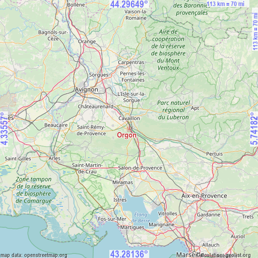
Orgon GPS coordinates[2]
43° 47' 27.888" North, 5° 2' 19.284" East
| Map corner | latitude | longitude |
|---|---|---|
| Upper-left | 44.29649°, | 4.33557° |
| Center: | 43.79108°, | 5.03869° |
| Lower-right: | 43.28136°, | 5.74182° |
| Map W x H: | 112.9×112.9 km | = 70.2×70.2mi |
| max Lat: | 51.07786° ⇑89.2% North |
| Orgon: | 43.79108° |
| min Lat: | ⇓10.8% South 41.3874° |
| min Long | Orgon | max Long |
| -5.08615° | 5.03869° | 9.52242° |
| W 78.1%⇐ | ⇒21.9% E |
Elevation
Elevation of Orgon is 97 m = 318 ft, and this is 96.7 m = 317 ft below average elevation for this country.
| Max E: |
2333 m = 7654 ft | 62% |
| Avg. | 193.7 m = 635 ft | |
| Orgon | 97 m = 318 ft | |
Min E: |
-1 m = -3 ft | 38% |
See also: France elevation on elevation.city.
Geographical zone
Orgon is located in North temperate zone (between Tropic of Cancer and the Arctic Circle). Distance of this Northern Tropic circle is 2263.2 km =1406.3 mi to South.| Distance of | km | miles | from Orgon |
|---|---|---|---|
| North Pole | 5138 | 3192.6 | to North |
| Arctic Circle | 2532.1 | 1573.4 | to North |
| Tropic Cancer | 2263.2 | 1406.3 | to South |
| Equator | 4869.1 | 3025.5 | to South |


Nearby cities:
15 places around Orgon: (largest is in red/bold)
• Aureille
11.8 km =7.3 mi,  218°
218°
• Cabannes
10.4 km =6.5 mi,  317°
317°
• Cavaillon
4.5 km =2.8 mi,  357°
357°
• Cheval-Blanc
2.2 km =1.4 mi,  57°
57°
• Eygalières
7.9 km =4.9 mi,  244°
244°
• Eyguières
10.7 km =6.6 mi,  183°
183°
• Lamanon
10.9 km =6.8 mi,  158°
158°
• Maubec
10 km =6.2 mi,  53°
53°
• Mollégès
7.4 km =4.6 mi,  283°
283°
• Oppède le Vieux
10.7 km =6.6 mi,  67°
67°
• Robion
8.5 km =5.3 mi,  42°
42°
• Saint-Andiol
9 km =5.6 mi,  302°
302°
• Sénas
6.1 km =3.8 mi,  149°
149°
• Taillades
6.6 km =4.1 mi, 38°
• Verquières
11.1 km =6.9 mi, 299°
Sources, notices
• [Note1] Compared only with cities in France existing in our database
• [Src1] Map data: © OpenStreetMap contributors (CC-BY-SA)
• [Src2] Other city data from geonames.org with taken over terms of usage.
• [Src3] Geographical zone / Annual Mean Temperature by Robert A. Rohde @ Wikipedia
