Eygalières geodata
Eygalières (Provence-Alpes-Côte d'Azur) is a populated place; located in France in Europe/Paris (GMT+2) time zone. With population of 1,913 people, there are 5005 cities with bigger population in this country. Compared to other cities in France, 89.6% of cities are located further ↑North; 77.1% of cities are located further ←West and 56.5% of cities have higher elevation than Eygalières. Note1
Administrative division(s):
- Level 1: Provence-Alpes-Côte d'Azur
- Level 2: Département des Bouches-du-Rhône
- Level 3: Arles
- Level 4: Eygalières


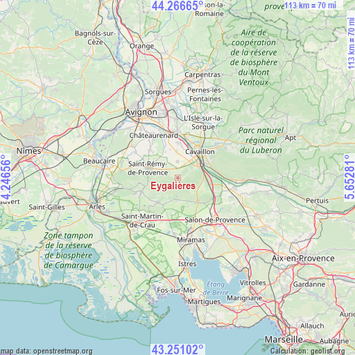
Eygalières GPS coordinates[2]
43° 45' 39.564" North, 4° 56' 58.848" East
| Map corner | latitude | longitude |
|---|---|---|
| Upper-left | 44.26665°, | 4.24656° |
| Center: | 43.76099°, | 4.94968° |
| Lower-right: | 43.25102°, | 5.65281° |
| Map W x H: | 112.9×112.9 km | = 70.2×70.2mi |
| max Lat: | 51.07786° ⇑89.6% North |
| Eygalières: | 43.76099° |
| min Lat: | ⇓10.4% South 41.3874° |
| min Long | Eygalières | max Long |
| -5.08615° | 4.94968° | 9.52242° |
| W 77.1%⇐ | ⇒22.9% E |
Elevation
Elevation of Eygalières is 112 m = 367 ft, and this is 81.7 m = 268 ft below average elevation for this country.
| Max E: |
2333 m = 7654 ft | 56.5% |
| Avg. | 193.7 m = 635 ft | |
| Eygalières | 112 m = 367 ft | |
Min E: |
-1 m = -3 ft | 43.5% |
See also: France elevation on elevation.city.
Geographical zone
Eygalières is located in North temperate zone (between Tropic of Cancer and the Arctic Circle). Distance of this Northern Tropic circle is 2259.8 km =1404.2 mi to South.| Distance of | km | miles | from Eygalières |
|---|---|---|---|
| North Pole | 5141.3 | 3194.7 | to North |
| Arctic Circle | 2535.4 | 1575.4 | to North |
| Tropic Cancer | 2259.8 | 1404.2 | to South |
| Equator | 4865.8 | 3023.5 | to South |


Nearby cities:
15 places around Eygalières: (largest is in red/bold)
• Aureille
5.9 km =3.7 mi,  181°
181°
• Cabannes
11 km =6.8 mi,  0°
0°
• Cavaillon
10.4 km =6.5 mi,  41°
41°
• Cheval-Blanc
10.1 km =6.3 mi,  63°
63°
• Eyguières
9.9 km =6.2 mi,  138°
138°
• Eyragues
12.4 km =7.7 mi,  315°
315°
• Lamanon
13.1 km =8.1 mi,  121°
121°
• Maussane-les-Alpilles
12.4 km =7.7 mi,  249°
249°
• Mollégès
5.1 km =3.2 mi,  359°
359°
• Mouriès
10.1 km =6.3 mi,  218°
218°
• Orgon
7.9 km =4.9 mi, 64°
• Saint-Andiol
8.2 km =5.1 mi, 357°
• Saint-Rémy-de-Provence
10 km =6.2 mi,  287°
287°
• Sénas
10.5 km =6.5 mi,  100°
100°
• Verquières
9.2 km =5.7 mi,  344°
344°
Sources, notices
• [Note1] Compared only with cities in France existing in our database
• [Src1] Map data: © OpenStreetMap contributors (CC-BY-SA)
• [Src2] Other city data from geonames.org with taken over terms of usage.
• [Src3] Geographical zone / Annual Mean Temperature by Robert A. Rohde @ Wikipedia
