Sénas geodata
Sénas (Provence-Alpes-Côte d'Azur) is a populated place; located in France in Europe/Paris (GMT+2) time zone. With population of 6,062 people, there are 1631 cities with bigger population in this country. Compared to other cities in France, 89.8% of cities are located further ↑North; 78.5% of cities are located further ←West and 62.4% of cities have higher elevation than Sénas. Note1
Administrative division(s):
- Level 1: Provence-Alpes-Côte d'Azur
- Level 2: Département des Bouches-du-Rhône
- Level 3: Aix-en-Provence
- Level 4: Sénas


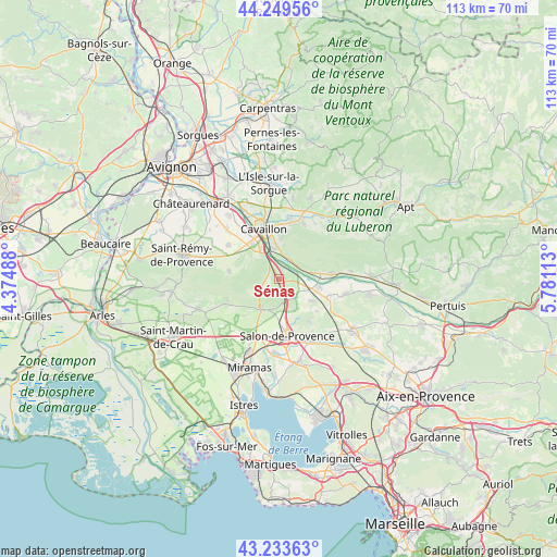
Sénas GPS coordinates[2]
43° 44' 37.5" North, 5° 4' 40.8" East
| Map corner | latitude | longitude |
|---|---|---|
| Upper-left | 44.24956°, | 4.37488° |
| Center: | 43.74375°, | 5.078° |
| Lower-right: | 43.23363°, | 5.78113° |
| Map W x H: | 113×113 km | = 70.2×70.2mi |
| max Lat: | 51.07786° ⇑89.8% North |
| Sénas: | 43.74375° |
| min Lat: | ⇓10.2% South 41.3874° |
| min Long | Sénas | max Long |
| -5.08615° | 5.078° | 9.52242° |
| W 78.5%⇐ | ⇒21.5% E |
Elevation
Elevation of Sénas is 96 m = 315 ft, and this is 97.7 m = 321 ft below average elevation for this country.
| Max E: |
2333 m = 7654 ft | 62.4% |
| Avg. | 193.7 m = 635 ft | |
| Sénas | 96 m = 315 ft | |
Min E: |
-1 m = -3 ft | 37.6% |
See also: France elevation on elevation.city.
Geographical zone
Sénas is located in North temperate zone (between Tropic of Cancer and the Arctic Circle). Distance of this Northern Tropic circle is 2257.9 km =1403 mi to South.| Distance of | km | miles | from Sénas |
|---|---|---|---|
| North Pole | 5143.2 | 3195.8 | to North |
| Arctic Circle | 2537.3 | 1576.6 | to North |
| Tropic Cancer | 2257.9 | 1403 | to South |
| Equator | 4863.8 | 3022.2 | to South |


Nearby cities:
15 places around Sénas: (largest is in red/bold)
• Alleins
8.1 km =5 mi,  123°
123°
• Aureille
11.2 km =7 mi,  249°
249°
• Aurons
10.8 km =6.7 mi,  143°
143°
• Cavaillon
10.3 km =6.4 mi,  340°
340°
• Cheval-Blanc
6.6 km =4.1 mi,  348°
348°
• Eygalières
10.5 km =6.5 mi,  280°
280°
• Eyguières
6.6 km =4.1 mi,  214°
214°
• Lamanon
5 km =3.1 mi,  170°
170°
• Mallemort
8.3 km =5.2 mi,  99°
99°
• Mérindol
10.2 km =6.3 mi,  82°
82°
• Oppède le Vieux
11.6 km =7.2 mi,  35°
35°
• Orgon
6.1 km =3.8 mi,  329°
329°
• Salon-de-Provence
11.4 km =7.1 mi, 173°
• Taillades
10.5 km =6.5 mi,  5°
5°
• Vernègues
9.9 km =6.2 mi,  130°
130°
Sources, notices
• [Note1] Compared only with cities in France existing in our database
• [Src1] Map data: © OpenStreetMap contributors (CC-BY-SA)
• [Src2] Other city data from geonames.org with taken over terms of usage.
• [Src3] Geographical zone / Annual Mean Temperature by Robert A. Rohde @ Wikipedia
