Cavaillon geodata
Cavaillon (Provence-Alpes-Côte d'Azur) is a populated place; located in France in Europe/Paris (GMT+2) time zone. With population of 26,689 people, there are 320 cities with bigger population in this country. Compared to other cities in France, 88.8% of cities are located further ↑North; 78.1% of cities are located further ←West and 73.1% of cities have higher elevation than Cavaillon. Note1
Administrative division(s):
- Level 1: Provence-Alpes-Côte d'Azur
- Level 2: Département du Vaucluse
- Level 3: Apt
- Level 4: Cavaillon


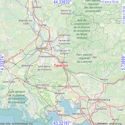
Cavaillon GPS coordinates[2]
43° 49' 52.5" North, 5° 2' 9.096" East
| Map corner | latitude | longitude |
|---|---|---|
| Upper-left | 44.33632°, | 4.33274° |
| Center: | 43.83125°, | 5.03586° |
| Lower-right: | 43.32187°, | 5.73899° |
| Map W x H: | 112.8×112.8 km | = 70.1×70.1mi |
| max Lat: | 51.07786° ⇑88.8% North |
| Cavaillon: | 43.83125° |
| min Lat: | ⇓11.2% South 41.3874° |
| min Long | Cavaillon | max Long |
| -5.08615° | 5.03586° | 9.52242° |
| W 78.1%⇐ | ⇒21.9% E |
Elevation
Elevation of Cavaillon is 71 m = 233 ft, and this is 122.7 m = 403 ft below average elevation for this country.
| Max E: |
2333 m = 7654 ft | 73.1% |
| Avg. | 193.7 m = 635 ft | |
| Cavaillon | 71 m = 233 ft | |
Min E: |
-1 m = -3 ft | 26.9% |
See also: France elevation on elevation.city.
Geographical zone
Cavaillon is located in North temperate zone (between Tropic of Cancer and the Arctic Circle). Distance of this Northern Tropic circle is 2267.7 km =1409.1 mi to South.| Distance of | km | miles | from Cavaillon |
|---|---|---|---|
| North Pole | 5133.5 | 3189.8 | to North |
| Arctic Circle | 2527.6 | 1570.6 | to North |
| Tropic Cancer | 2267.7 | 1409.1 | to South |
| Equator | 4873.6 | 3028.3 | to South |


Nearby cities:
15 places around Cavaillon: (largest is in red/bold)
• Cabannes
7.5 km =4.7 mi,  295°
295°
• Caumont-sur-Durance
9.9 km =6.2 mi,  314°
314°
• Cheval-Blanc
3.9 km =2.4 mi,  146°
146°
• Eygalières
10.4 km =6.5 mi,  221°
221°
• Lagnes
9.4 km =5.8 mi,  42°
42°
• L’Isle-sur-la-Sorgue
9.9 km =6.2 mi,  7°
7°
• Maubec
8.4 km =5.2 mi,  80°
80°
• Mollégès
7.4 km =4.6 mi,  248°
248°
• Oppède le Vieux
10.1 km =6.3 mi,  91°
91°
• Orgon
4.5 km =2.8 mi,  177°
177°
• Robion
6.2 km =3.9 mi,  73°
73°
• Saint-Andiol
7.3 km =4.5 mi,  273°
273°
• Sénas
10.3 km =6.4 mi,  160°
160°
• Taillades
4.4 km =2.7 mi, 80°
• Verquières
9.4 km =5.8 mi,  276°
276°
Sources, notices
• [Note1] Compared only with cities in France existing in our database
• [Src1] Map data: © OpenStreetMap contributors (CC-BY-SA)
• [Src2] Other city data from geonames.org with taken over terms of usage.
• [Src3] Geographical zone / Annual Mean Temperature by Robert A. Rohde @ Wikipedia
