Ondres geodata
Ondres (Nouvelle-Aquitaine) is a populated place; located in France in Europe/Paris (GMT+2) time zone. With population of 3,983 people, there are 2468 cities with bigger population in this country. Compared to other cities in France, 92.3% of cities are located further ↑North; 91.9% of cities are located further →East and 90.3% of cities have higher elevation than Ondres. Note1
Administrative division(s):
- Level 1: Nouvelle-Aquitaine
- Level 2: Landes
- Level 3: Arrondissement de Dax
- Level 4: Ondres


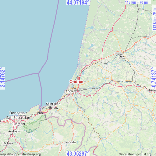
Ondres GPS coordinates[2]
43° 33' 52.596" North, 1° 26' 40.164" West
| Map corner | latitude | longitude |
|---|---|---|
| Upper-left | 44.07194°, | -2.14762° |
| Center: | 43.56461°, | -1.44449° |
| Lower-right: | 43.05297°, | -0.74137° |
| Map W x H: | 113.3×113.3 km | = 70.4×70.4mi |
| max Lat: | 51.07786° ⇑92.3% North |
| Ondres: | 43.56461° |
| min Lat: | ⇓7.7% South 41.3874° |
| min Long | Ondres | max Long |
| -5.08615° | -1.44449° | 9.52242° |
| W 8.1%⇐ | ⇒91.9% E |
Elevation
Elevation of Ondres is 29 m = 95 ft, and this is 164.7 m = 540 ft below average elevation for this country.
| Max E: |
2333 m = 7654 ft | 90.3% |
| Avg. | 193.7 m = 635 ft | |
| Ondres | 29 m = 95 ft | |
Min E: |
-1 m = -3 ft | 9.7% |
See also: France elevation on elevation.city.
Geographical zone
Ondres is located in North temperate zone (between Tropic of Cancer and the Arctic Circle). Distance of this Northern Tropic circle is 2238 km =1390.6 mi to South.| Distance of | km | miles | from Ondres |
|---|---|---|---|
| North Pole | 5163.1 | 3208.2 | to North |
| Arctic Circle | 2557.2 | 1589 | to North |
| Tropic Cancer | 2238 | 1390.6 | to South |
| Equator | 4843.9 | 3009.9 | to South |


Nearby cities:
15 places around Ondres: (largest is in red/bold)
• Anglet
11.3 km =7 mi,  209°
209°
• Angresse
11.9 km =7.4 mi,  29°
29°
• Bayonne
8.4 km =5.2 mi,  197°
197°
• Biaudos
11.2 km =7 mi,  97°
97°
• Boucau
4.4 km =2.7 mi, 202°
• Bénesse-Maremne
10.6 km =6.6 mi,  41°
41°
• Capbreton
8.7 km =5.4 mi,  8°
8°
• Labenne
3.7 km =2.3 mi,  24°
24°
• Lahonce
10.1 km =6.3 mi,  154°
154°
• Mouguerre
11 km =6.8 mi,  168°
168°
• Saint-André-de-Seignanx
7.5 km =4.7 mi, 95°
• Saint-Martin-de-Seignanx
5.1 km =3.2 mi,  118°
118°
• Saubrigues
11.7 km =7.3 mi,  64°
64°
• Soorts-Hossegor
11.8 km =7.3 mi, 18°
• Tarnos
2.9 km =1.8 mi, 210°
Sources, notices
• [Note1] Compared only with cities in France existing in our database
• [Src1] Map data: © OpenStreetMap contributors (CC-BY-SA)
• [Src2] Other city data from geonames.org with taken over terms of usage.
• [Src3] Geographical zone / Annual Mean Temperature by Robert A. Rohde @ Wikipedia
