Boucau geodata
Boucau (Nouvelle-Aquitaine) is a populated place; located in France in Europe/Paris (GMT+2) time zone. With population of 7,532 people, there are 1292 cities with bigger population in this country. Compared to other cities in France, 92.7% of cities are located further ↑North; 92% of cities are located further →East and 88.3% of cities have higher elevation than Boucau. Note1
Administrative division(s):
- Level 1: Nouvelle-Aquitaine
- Level 2: Département des Pyrénées-Atlantiques
- Level 3: Arrondissement de Bayonne
- Level 4: Boucau


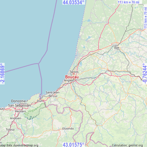
Boucau GPS coordinates[2]
43° 31' 39.72" North, 1° 27' 56.016" West
| Map corner | latitude | longitude |
|---|---|---|
| Upper-left | 44.03534°, | -2.16869° |
| Center: | 43.5277°, | -1.46556° |
| Lower-right: | 43.01575°, | -0.76244° |
| Map W x H: | 113.4×113.4 km | = 70.5×70.5mi |
| max Lat: | 51.07786° ⇑92.7% North |
| Boucau: | 43.5277° |
| min Lat: | ⇓7.3% South 41.3874° |
| min Long | Boucau | max Long |
| -5.08615° | -1.46556° | 9.52242° |
| W 8%⇐ | ⇒92% E |
Elevation
Elevation of Boucau is 34 m = 112 ft, and this is 159.7 m = 524 ft below average elevation for this country.
| Max E: |
2333 m = 7654 ft | 88.3% |
| Avg. | 193.7 m = 635 ft | |
| Boucau | 34 m = 112 ft | |
Min E: |
-1 m = -3 ft | 11.7% |
See also: France elevation on elevation.city.
Geographical zone
Boucau is located in North temperate zone (between Tropic of Cancer and the Arctic Circle). Distance of this Northern Tropic circle is 2233.9 km =1388.1 mi to South.| Distance of | km | miles | from Boucau |
|---|---|---|---|
| North Pole | 5167.2 | 3210.7 | to North |
| Arctic Circle | 2561.3 | 1591.5 | to North |
| Tropic Cancer | 2233.9 | 1388.1 | to South |
| Equator | 4839.8 | 3007.3 | to South |


Nearby cities:
15 places around Boucau: (largest is in red/bold)
• Anglet
6.9 km =4.3 mi,  214°
214°
• Arbonne
12.6 km =7.8 mi, 213°
• Arcangues
11.7 km =7.3 mi,  203°
203°
• Bassussarry
10.3 km =6.4 mi, 203°
• Bayonne
4 km =2.5 mi,  192°
192°
• Biarritz
9 km =5.6 mi,  233°
233°
• Labenne
8.1 km =5 mi,  23°
23°
• Lahonce
7.8 km =4.8 mi,  129°
129°
• Mouguerre
7.7 km =4.8 mi,  150°
150°
• Ondres
4.4 km =2.7 mi, 22°
• Saint-André-de-Seignanx
9.8 km =6.1 mi,  69°
69°
• Saint-Martin-de-Seignanx
6.4 km =4 mi, 74°
• Tarnos
1.6 km =1 mi,  8°
8°
• Urcuit
11.4 km =7.1 mi,  114°
114°
• Villefranque
10.2 km =6.3 mi,  174°
174°
Sources, notices
• [Note1] Compared only with cities in France existing in our database
• [Src1] Map data: © OpenStreetMap contributors (CC-BY-SA)
• [Src2] Other city data from geonames.org with taken over terms of usage.
• [Src3] Geographical zone / Annual Mean Temperature by Robert A. Rohde @ Wikipedia
