Bayonne geodata
Bayonne (Nouvelle-Aquitaine) is a seat of a third-order administrative division; located in France in Europe/Paris (GMT+2) time zone. With population of 44,396 people, there are 155 cities with bigger population in this country. Compared to other cities in France, 93.1% of cities are located further ↑North; 92.1% of cities are located further →East and 99.3% of cities have higher elevation than Bayonne. Note1
Administrative division(s):
- Level 1: Nouvelle-Aquitaine
- Level 2: Département des Pyrénées-Atlantiques
- Level 3: Arrondissement de Bayonne
- Level 4: Bayonne


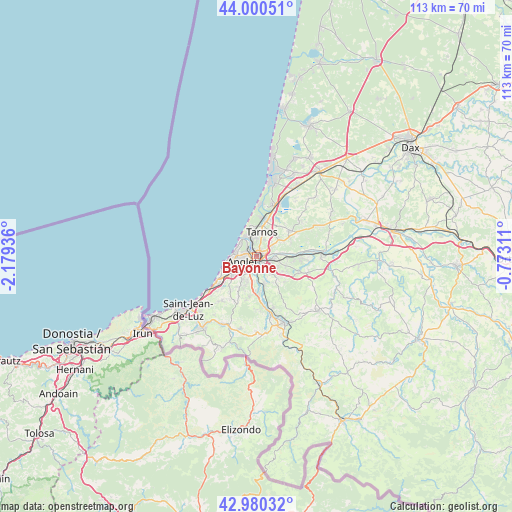
Bayonne GPS coordinates[2]
43° 29' 33.252" North, 1° 28' 34.464" West
| Map corner | latitude | longitude |
|---|---|---|
| Upper-left | 44.00051°, | -2.17936° |
| Center: | 43.49257°, | -1.47624° |
| Lower-right: | 42.98032°, | -0.77311° |
| Map W x H: | 113.4×113.4 km | = 70.5×70.5mi |
| max Lat: | 51.07786° ⇑93.1% North |
| Bayonne: | 43.49257° |
| min Lat: | ⇓6.9% South 41.3874° |
| min Long | Bayonne | max Long |
| -5.08615° | -1.47624° | 9.52242° |
| W 7.9%⇐ | ⇒92.1% E |
Elevation
Elevation of Bayonne is 5 m = 16 ft, and this is 188.7 m = 619 ft below average elevation for this country.
| Max E: |
2333 m = 7654 ft | 99.3% |
| Avg. | 193.7 m = 635 ft | |
| Bayonne | 5 m = 16 ft | |
Min E: |
-1 m = -3 ft | 0.7% |
See also: Bayonne elevation on elevation.city.
Geographical zone
Bayonne is located in North temperate zone (between Tropic of Cancer and the Arctic Circle). Distance of this Northern Tropic circle is 2230 km =1385.7 mi to South.| Distance of | km | miles | from Bayonne |
|---|---|---|---|
| North Pole | 5171.1 | 3213.2 | to North |
| Arctic Circle | 2565.3 | 1594 | to North |
| Tropic Cancer | 2230 | 1385.7 | to South |
| Equator | 4835.9 | 3004.9 | to South |


Nearby cities:
15 places around Bayonne: (largest is in red/bold)
• Anglet
3.5 km =2.2 mi,  239°
239°
• Arbonne
9 km =5.6 mi,  222°
222°
• Arcangues
7.8 km =4.8 mi,  208°
208°
• Bassussarry
6.4 km =4 mi, 210°
• Biarritz
6.5 km =4 mi,  257°
257°
• Bidart
11.1 km =6.9 mi, 236°
• Boucau
4 km =2.5 mi,  12°
12°
• Lahonce
7 km =4.3 mi,  99°
99°
• Mouguerre
5.4 km =3.4 mi,  120°
120°
• Ondres
8.4 km =5.2 mi,  17°
17°
• Saint-Martin-de-Seignanx
9 km =5.6 mi,  51°
51°
• Tarnos
5.6 km =3.5 mi, 11°
• Urcuit
11.3 km =7 mi,  93°
93°
• Ustaritz
10.8 km =6.7 mi,  171°
171°
• Villefranque
6.5 km =4 mi,  163°
163°
Sources, notices
• [Note1] Compared only with cities in France existing in our database
• [Src1] Map data: © OpenStreetMap contributors (CC-BY-SA)
• [Src2] Other city data from geonames.org with taken over terms of usage.
• [Src3] Geographical zone / Annual Mean Temperature by Robert A. Rohde @ Wikipedia
