Oisemont geodata
Oisemont (Hauts-de-France) is a populated place; located in France in Europe/Paris (GMT+2) time zone. With population of 1,328 people, there are 6901 cities with bigger population in this country. Compared to other cities in France, 93.3% of cities are located further ↓South; 59.8% of cities are located further →East and 53.1% of cities have higher elevation than Oisemont. Note1
Administrative division(s):
- Level 1: Hauts-de-France
- Level 2: Somme
- Level 3: Amiens
- Level 4: Oisemont


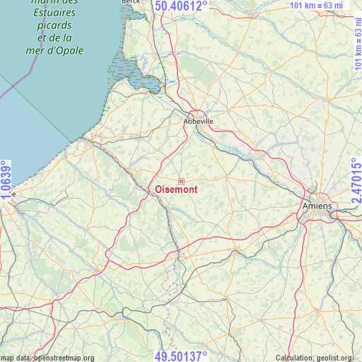
Oisemont GPS coordinates[2]
49° 57' 21.132" North, 1° 46' 1.308" East
| Map corner | latitude | longitude |
|---|---|---|
| Upper-left | 50.40612°, | 1.0639° |
| Center: | 49.95587°, | 1.76703° |
| Lower-right: | 49.50137°, | 2.47015° |
| Map W x H: | 100.6×100.6 km | = 62.5×62.5mi |
| max Lat: | 51.07786° ⇑6.7% North |
| Oisemont: | 49.95587° |
| min Lat: | ⇓93.3% South 41.3874° |
| min Long | Oisemont | max Long |
| -5.08615° | 1.76703° | 9.52242° |
| W 40.2%⇐ | ⇒59.8% E |
Elevation
Elevation of Oisemont is 122 m = 400 ft, and this is 71.7 m = 235 ft below average elevation for this country.
| Max E: |
2333 m = 7654 ft | 53.1% |
| Avg. | 193.7 m = 635 ft | |
| Oisemont | 122 m = 400 ft | |
Min E: |
-1 m = -3 ft | 46.9% |
See also: France elevation on elevation.city.
Geographical zone
Oisemont is located in North temperate zone (between Tropic of Cancer and the Arctic Circle). Distance of this North polar circle is 1846.6 km =1147.4 mi to North.| Distance of | km | miles | from Oisemont |
|---|---|---|---|
| North Pole | 4452.5 | 2766.7 | to North |
| Arctic Circle | 1846.6 | 1147.4 | to North |
| Tropic Cancer | 2948.7 | 1832.2 | to South |
| Equator | 5554.6 | 3451.5 | to South |


Nearby cities:
15 places around Oisemont: (largest is in red/bold)
• Airaines
12.6 km =7.8 mi,  83°
83°
• Allery
9.4 km =5.8 mi, 84°
• Beaucamps-le-Vieux
12.2 km =7.6 mi,  174°
174°
• Blangy-sur-Bresle
10.5 km =6.5 mi,  255°
255°
• Bouttencourt
9.7 km =6 mi, 257°
• Hallencourt
8.8 km =5.5 mi,  62°
62°
• Huchenneville
10.9 km =6.8 mi,  12°
12°
• Huppy
7.7 km =4.8 mi,  358°
358°
• Maisnières
12.5 km =7.8 mi,  301°
301°
• Mareuil-Caubert
13.3 km =8.3 mi,  19°
19°
• Monchaux-Soreng
12.4 km =7.7 mi,  266°
266°
• Moyenneville
12.8 km =8 mi,  354°
354°
• Neuville-Coppegueule
12.1 km =7.5 mi,  184°
184°
• Senarpont
8.2 km =5.1 mi,  204°
204°
• Tours-en-Vimeu
10.6 km =6.6 mi,  326°
326°
Sources, notices
• [Note1] Compared only with cities in France existing in our database
• [Src1] Map data: © OpenStreetMap contributors (CC-BY-SA)
• [Src2] Other city data from geonames.org with taken over terms of usage.
• [Src3] Geographical zone / Annual Mean Temperature by Robert A. Rohde @ Wikipedia
