Huppy geodata
Huppy (Hauts-de-France) is a populated place; located in France in Europe/Paris (GMT+2) time zone. With population of 709 people, there are 11666 cities with bigger population in this country. Compared to other cities in France, 93.7% of cities are located further ↓South; 59.8% of cities are located further →East and 60.4% of cities have higher elevation than Huppy. Note1
Administrative division(s):
- Level 1: Hauts-de-France
- Level 2: Somme
- Level 3: Abbeville
- Level 4: Huppy


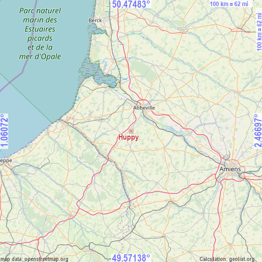
Huppy GPS coordinates[2]
50° 1' 30.828" North, 1° 45' 49.86" East
| Map corner | latitude | longitude |
|---|---|---|
| Upper-left | 50.47483°, | 1.06072° |
| Center: | 50.02523°, | 1.76385° |
| Lower-right: | 49.57138°, | 2.46697° |
| Map W x H: | 100.5×100.5 km | = 62.4×62.4mi |
| max Lat: | 51.07786° ⇑6.3% North |
| Huppy: | 50.02523° |
| min Lat: | ⇓93.7% South 41.3874° |
| min Long | Huppy | max Long |
| -5.08615° | 1.76385° | 9.52242° |
| W 40.2%⇐ | ⇒59.8% E |
Elevation
Elevation of Huppy is 101 m = 331 ft, and this is 92.7 m = 304 ft below average elevation for this country.
| Max E: |
2333 m = 7654 ft | 60.4% |
| Avg. | 193.7 m = 635 ft | |
| Huppy | 101 m = 331 ft | |
Min E: |
-1 m = -3 ft | 39.6% |
See also: France elevation on elevation.city.
Geographical zone
Huppy is located in North temperate zone (between Tropic of Cancer and the Arctic Circle). Distance of this North polar circle is 1838.9 km =1142.6 mi to North.| Distance of | km | miles | from Huppy |
|---|---|---|---|
| North Pole | 4444.8 | 2761.9 | to North |
| Arctic Circle | 1838.9 | 1142.6 | to North |
| Tropic Cancer | 2956.4 | 1837 | to South |
| Equator | 5562.3 | 3456.3 | to South |


Nearby cities:
15 places around Huppy: (largest is in red/bold)
• Abbeville
10.3 km =6.4 mi,  29°
29°
• Acheux-en-Vimeu
7.7 km =4.8 mi,  305°
305°
• Aigneville
10.3 km =6.4 mi,  275°
275°
• Cambron
9.5 km =5.9 mi,  2°
2°
• Chépy
9.4 km =5.8 mi,  297°
297°
• Hallencourt
8.9 km =5.5 mi,  114°
114°
• Huchenneville
3.9 km =2.4 mi,  41°
41°
• Maisnières
10.5 km =6.5 mi,  263°
263°
• Mareuil-Caubert
6.7 km =4.2 mi, 44°
• Miannay
8.6 km =5.3 mi,  337°
337°
• Moyenneville
5.2 km =3.2 mi,  349°
349°
• Oisemont
7.7 km =4.8 mi,  178°
178°
• Quesnoy-le-Montant
10.9 km =6.8 mi,  330°
330°
• Tours-en-Vimeu
5.8 km =3.6 mi, 280°
• Épagne-Épagnette
9.4 km =5.8 mi,  56°
56°
Sources, notices
• [Note1] Compared only with cities in France existing in our database
• [Src1] Map data: © OpenStreetMap contributors (CC-BY-SA)
• [Src2] Other city data from geonames.org with taken over terms of usage.
• [Src3] Geographical zone / Annual Mean Temperature by Robert A. Rohde @ Wikipedia
