Neuville-Coppegueule geodata
Neuville-Coppegueule (Hauts-de-France) is a populated place; located in France in Europe/Paris (GMT+2) time zone. With population of 545 people, there are 14306 cities with bigger population in this country. Compared to other cities in France, 92.6% of cities are located further ↓South; 60% of cities are located further →East and 64.9% of cities have lower elevation than Neuville-Coppegueule. Note1
Administrative division(s):
- Level 1: Hauts-de-France
- Level 2: Somme
- Level 3: Amiens
- Level 4: Neuville-Coppegueule


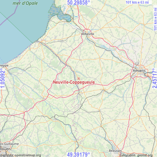
Neuville-Coppegueule GPS coordinates[2]
49° 50' 50.316" North, 1° 45' 14.544" East
| Map corner | latitude | longitude |
|---|---|---|
| Upper-left | 50.29858°, | 1.05092° |
| Center: | 49.84731°, | 1.75404° |
| Lower-right: | 49.39179°, | 2.45717° |
| Map W x H: | 100.8×100.8 km | = 62.6×62.6mi |
| max Lat: | 51.07786° ⇑7.4% North |
| Neuville-Coppegueule: | 49.84731° |
| min Lat: | ⇓92.6% South 41.3874° |
| min Long | Neuville-Coppeg | max Long |
| -5.08615° | 1.75404° | 9.52242° |
| W 40%⇐ | ⇒60% E |
Elevation
Elevation of Neuville-Coppegueule is 193 m = 633 ft, and this is 0.69999999999999 m = 2 ft below average elevation for this country.
| Max E: |
2333 m = 7654 ft | 35.1% |
| Avg. | 193.7 m = 635 ft | |
| Neuville-Coppegueule | 193 m = 633 ft | |
Min E: |
-1 m = -3 ft | 64.9% |
See also: France elevation on elevation.city.
Geographical zone
Neuville-Coppegueule is located in North temperate zone (between Tropic of Cancer and the Arctic Circle). Distance of this North polar circle is 1858.7 km =1154.9 mi to North.| Distance of | km | miles | from Neuville-Coppegueule |
|---|---|---|---|
| North Pole | 4464.6 | 2774.2 | to North |
| Arctic Circle | 1858.7 | 1154.9 | to North |
| Tropic Cancer | 2936.6 | 1824.7 | to South |
| Equator | 5542.5 | 3443.9 | to South |


Nearby cities:
15 places around Neuville-Coppegueule: (largest is in red/bold)
• Abancourt
16.8 km =10.4 mi,  177°
177°
• Allery
16.6 km =10.3 mi,  38°
38°
• Aumale
8.6 km =5.3 mi, 179°
• Beaucamps-le-Vieux
2.1 km =1.3 mi,  92°
92°
• Blangy-sur-Bresle
13.2 km =8.2 mi,  315°
315°
• Bouttencourt
13.2 km =8.2 mi, 319°
• Foucarmont
13.3 km =8.3 mi,  269°
269°
• Hornoy-le-Bourg
10.5 km =6.5 mi, 88°
• Monchaux-Soreng
16.1 km =10 mi,  314°
314°
• Oisemont
12.1 km =7.5 mi,  4°
4°
• Poix-de-Picardie
17.9 km =11.1 mi,  113°
113°
• Rieux
15.8 km =9.8 mi, 308°
• Romescamps
15.6 km =9.7 mi,  166°
166°
• Senarpont
5.2 km =3.2 mi,  331°
331°
• Vieux-Rouen-sur-Bresle
2.9 km =1.8 mi,  238°
238°
Sources, notices
• [Note1] Compared only with cities in France existing in our database
• [Src1] Map data: © OpenStreetMap contributors (CC-BY-SA)
• [Src2] Other city data from geonames.org with taken over terms of usage.
• [Src3] Geographical zone / Annual Mean Temperature by Robert A. Rohde @ Wikipedia
