Allery geodata
Allery (Hauts-de-France) is a populated place; located in France in Europe/Paris (GMT+2) time zone. With population of 766 people, there are 10996 cities with bigger population in this country. Compared to other cities in France, 93.4% of cities are located further ↓South; 58.3% of cities are located further →East and 85.3% of cities have higher elevation than Allery. Note1
Administrative division(s):
- Level 1: Hauts-de-France
- Level 2: Somme
- Level 3: Abbeville
- Level 4: Allery


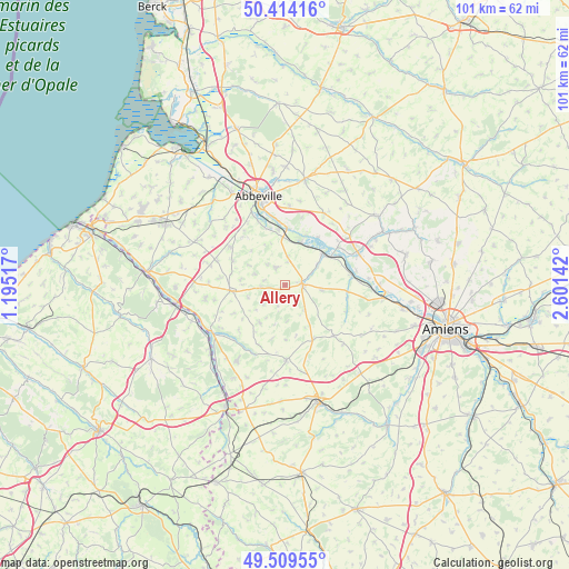
Allery GPS coordinates[2]
49° 57' 50.328" North, 1° 53' 53.844" East
| Map corner | latitude | longitude |
|---|---|---|
| Upper-left | 50.41416°, | 1.19517° |
| Center: | 49.96398°, | 1.89829° |
| Lower-right: | 49.50955°, | 2.60142° |
| Map W x H: | 100.6×100.6 km | = 62.5×62.5mi |
| max Lat: | 51.07786° ⇑6.6% North |
| Allery: | 49.96398° |
| min Lat: | ⇓93.4% South 41.3874° |
| min Long | Allery | max Long |
| -5.08615° | 1.89829° | 9.52242° |
| W 41.7%⇐ | ⇒58.3% E |
Elevation
Elevation of Allery is 41 m = 135 ft, and this is 152.7 m = 501 ft below average elevation for this country.
| Max E: |
2333 m = 7654 ft | 85.3% |
| Avg. | 193.7 m = 635 ft | |
| Allery | 41 m = 135 ft | |
Min E: |
-1 m = -3 ft | 14.7% |
See also: France elevation on elevation.city.
Geographical zone
Allery is located in North temperate zone (between Tropic of Cancer and the Arctic Circle). Distance of this North polar circle is 1845.7 km =1146.9 mi to North.| Distance of | km | miles | from Allery |
|---|---|---|---|
| North Pole | 4451.6 | 2766.1 | to North |
| Arctic Circle | 1845.7 | 1146.9 | to North |
| Tropic Cancer | 2949.6 | 1832.8 | to South |
| Equator | 5555.5 | 3452 | to South |


Nearby cities:
15 places around Allery: (largest is in red/bold)
• Airaines
3.2 km =2 mi,  81°
81°
• Condé-Folie
9.6 km =6 mi,  58°
58°
• Flixecourt
14.2 km =8.8 mi,  66°
66°
• Hallencourt
3.5 km =2.2 mi,  333°
333°
• Hangest-sur-Somme
12 km =7.5 mi, 81°
• Hornoy-le-Bourg
12.7 km =7.9 mi,  179°
179°
• Huchenneville
12 km =7.5 mi,  324°
324°
• Huppy
11.8 km =7.3 mi,  305°
305°
• Long
10.3 km =6.4 mi,  34°
34°
• Longpré-les-Corps-Saints
8.6 km =5.3 mi,  51°
51°
• Mareuil-Caubert
12.6 km =7.8 mi,  337°
337°
• Molliens-Dreuil
12.3 km =7.6 mi,  136°
136°
• Oisemont
9.4 km =5.8 mi,  264°
264°
• Pont-Remy
9.7 km =6 mi,  7°
7°
• Épagne-Épagnette
12.1 km =7.5 mi,  351°
351°
Sources, notices
• [Note1] Compared only with cities in France existing in our database
• [Src1] Map data: © OpenStreetMap contributors (CC-BY-SA)
• [Src2] Other city data from geonames.org with taken over terms of usage.
• [Src3] Geographical zone / Annual Mean Temperature by Robert A. Rohde @ Wikipedia
