Oger geodata
Oger (Grand Est) is a populated place; located in France in Europe/Paris (GMT+2) time zone. With population of 572 people, there are 13802 cities with bigger population in this country. Compared to other cities in France, 78.7% of cities are located further ↓South; 68% of cities are located further ←West and 53.8% of cities have higher elevation than Oger. Note1
Administrative division(s):
- Level 1: Grand Est
- Level 2: Marne
- Level 3: Arrondissement d'Épernay
- Level 4: Blancs-Coteaux


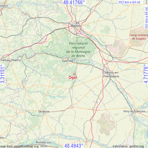
Oger GPS coordinates[2]
48° 57' 29.232" North, 4° 0' 52.704" East
| Map corner | latitude | longitude |
|---|---|---|
| Upper-left | 49.41766°, | 3.31151° |
| Center: | 48.95812°, | 4.01464° |
| Lower-right: | 48.4943°, | 4.71776° |
| Map W x H: | 102.7×102.7 km | = 63.8×63.8mi |
| max Lat: | 51.07786° ⇑21.3% North |
| Oger: | 48.95812° |
| min Lat: | ⇓78.7% South 41.3874° |
| min Long | Oger | max Long |
| -5.08615° | 4.01464° | 9.52242° |
| W 68%⇐ | ⇒32% E |
Elevation
Elevation of Oger is 120 m = 394 ft, and this is 73.7 m = 242 ft below average elevation for this country.
| Max E: |
2333 m = 7654 ft | 53.8% |
| Avg. | 193.7 m = 635 ft | |
| Oger | 120 m = 394 ft | |
Min E: |
-1 m = -3 ft | 46.2% |
See also: France elevation on elevation.city.
Geographical zone
Oger is located in North temperate zone (between Tropic of Cancer and the Arctic Circle). Distance of this North polar circle is 1957.5 km =1216.3 mi to North.| Distance of | km | miles | from Oger |
|---|---|---|---|
| North Pole | 4563.4 | 2835.6 | to North |
| Arctic Circle | 1957.5 | 1216.3 | to North |
| Tropic Cancer | 2837.7 | 1763.3 | to South |
| Equator | 5443.6 | 3382.5 | to South |


Nearby cities:
15 places around Oger: (largest is in red/bold)
• Athis
10.5 km =6.5 mi,  51°
51°
• Avize
1.7 km =1.1 mi,  359°
359°
• Bergères-lès-Vertus
8.7 km =5.4 mi,  184°
184°
• Chouilly
7.5 km =4.7 mi, 359°
• Cramant
3.7 km =2.3 mi,  333°
333°
• Grauves
4.1 km =2.5 mi,  295°
295°
• Le Mesnil-sur-Oger
1.4 km =0.9 mi,  154°
154°
• Mareuil-sur-Ay
9.9 km =6.2 mi,  9°
9°
• Moussy
9.4 km =5.8 mi,  313°
313°
• Oiry
7.8 km =4.8 mi,  20°
20°
• Pierry
8.8 km =5.5 mi,  322°
322°
• Plivot
7.8 km =4.8 mi,  31°
31°
• Vertus
5.9 km =3.7 mi,  188°
188°
• Vinay
10.3 km =6.4 mi, 304°
• Épernay
10 km =6.2 mi,  336°
336°
Sources, notices
• [Note1] Compared only with cities in France existing in our database
• [Src1] Map data: © OpenStreetMap contributors (CC-BY-SA)
• [Src2] Other city data from geonames.org with taken over terms of usage.
• [Src3] Geographical zone / Annual Mean Temperature by Robert A. Rohde @ Wikipedia
