Le Mesnil-sur-Oger geodata
Le Mesnil-sur-Oger (Grand Est) is a populated place; located in France in Europe/Paris (GMT+2) time zone. With population of 1,094 people, there are 8167 cities with bigger population in this country. Compared to other cities in France, 78.5% of cities are located further ↓South; 68% of cities are located further ←West and 53.1% of cities have higher elevation than Le Mesnil-sur-Oger. Note1
Administrative division(s):
- Level 1: Grand Est
- Level 2: Marne
- Level 3: Arrondissement d'Épernay
- Level 4: Le Mesnil-sur-Oger


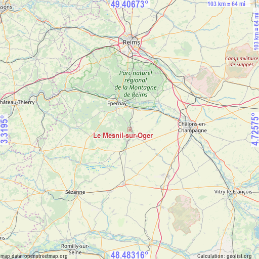
Le Mesnil-sur-Oger GPS coordinates[2]
48° 56' 49.488" North, 4° 1' 21.468" East
| Map corner | latitude | longitude |
|---|---|---|
| Upper-left | 49.40673°, | 3.3195° |
| Center: | 48.94708°, | 4.02263° |
| Lower-right: | 48.48316°, | 4.72575° |
| Map W x H: | 102.7×102.7 km | = 63.8×63.8mi |
| max Lat: | 51.07786° ⇑21.5% North |
| Le Mesnil-sur-Oger: | 48.94708° |
| min Lat: | ⇓78.5% South 41.3874° |
| min Long | Le Mesnil-sur-O | max Long |
| -5.08615° | 4.02263° | 9.52242° |
| W 68%⇐ | ⇒32% E |
Elevation
Elevation of Le Mesnil-sur-Oger is 122 m = 400 ft, and this is 71.7 m = 235 ft below average elevation for this country.
| Max E: |
2333 m = 7654 ft | 53.1% |
| Avg. | 193.7 m = 635 ft | |
| Le Mesnil-sur-Oger | 122 m = 400 ft | |
Min E: |
-1 m = -3 ft | 46.9% |
See also: France elevation on elevation.city.
Geographical zone
Le Mesnil-sur-Oger is located in North temperate zone (between Tropic of Cancer and the Arctic Circle). Distance of this North polar circle is 1958.8 km =1217.1 mi to North.| Distance of | km | miles | from Le Mesnil-sur-Oger |
|---|---|---|---|
| North Pole | 4564.7 | 2836.4 | to North |
| Arctic Circle | 1958.8 | 1217.1 | to North |
| Tropic Cancer | 2836.5 | 1762.5 | to South |
| Equator | 5442.4 | 3381.7 | to South |


Nearby cities:
15 places around Le Mesnil-sur-Oger: (largest is in red/bold)
• Athis
10.9 km =6.8 mi,  44°
44°
• Avize
3 km =1.9 mi,  348°
348°
• Bergères-lès-Vertus
7.6 km =4.7 mi,  189°
189°
• Chouilly
8.7 km =5.4 mi,  355°
355°
• Cramant
5.1 km =3.2 mi,  333°
333°
• Grauves
5.2 km =3.2 mi,  305°
305°
• Mareuil-sur-Ay
11 km =6.8 mi,  5°
5°
• Moussy
10.6 km =6.6 mi,  315°
315°
• Oger
1.4 km =0.9 mi, 334°
• Oiry
8.8 km =5.5 mi, 14°
• Pierry
10.1 km =6.3 mi, 323°
• Plivot
8.6 km =5.3 mi,  24°
24°
• Vertus
4.8 km =3 mi,  198°
198°
• Vinay
11.5 km =7.1 mi, 308°
• Épernay
11.3 km =7 mi,  335°
335°
Sources, notices
• [Note1] Compared only with cities in France existing in our database
• [Src1] Map data: © OpenStreetMap contributors (CC-BY-SA)
• [Src2] Other city data from geonames.org with taken over terms of usage.
• [Src3] Geographical zone / Annual Mean Temperature by Robert A. Rohde @ Wikipedia
