Donzenac geodata
Donzenac (Nouvelle-Aquitaine) is a populated place; located in France in Europe/Paris (GMT+2) time zone. With population of 2,277 people, there are 4230 cities with bigger population in this country. Compared to other cities in France, 77.1% of cities are located further ↑North; 62.7% of cities are located further →East and 68.1% of cities have lower elevation than Donzenac. Note1
Administrative division(s):
- Level 1: Nouvelle-Aquitaine
- Level 2: Département de la Corrèze
- Level 3: Arrondissement de Brive-la-Gaillarde
- Level 4: Donzenac


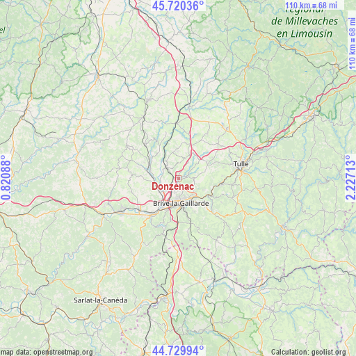
Donzenac GPS coordinates[2]
45° 13' 38.316" North, 1° 31' 26.4" East
| Map corner | latitude | longitude |
|---|---|---|
| Upper-left | 45.72036°, | 0.82088° |
| Center: | 45.22731°, | 1.524° |
| Lower-right: | 44.72994°, | 2.22713° |
| Map W x H: | 110.1×110.1 km | = 68.4×68.4mi |
| max Lat: | 51.07786° ⇑77.1% North |
| Donzenac: | 45.22731° |
| min Lat: | ⇓22.9% South 41.3874° |
| min Long | Donzenac | max Long |
| -5.08615° | 1.524° | 9.52242° |
| W 37.3%⇐ | ⇒62.7% E |
Elevation
Elevation of Donzenac is 210 m = 689 ft, and this is 16.3 m = 53 ft above average elevation for this country.
| Max E: |
2333 m = 7654 ft | 31.9% |
| Donzenac | 210 m 689 ft | |
| Avg. | 193.7 m = 635 ft | |
Min E: |
-1 m = -3 ft | 68.1% |
See also: France elevation on elevation.city.
Geographical zone
Donzenac is located in North temperate zone (between Tropic of Cancer and the Arctic Circle). Distance of this North polar circle is 2372.4 km =1474.1 mi to North.| Distance of | km | miles | from Donzenac |
|---|---|---|---|
| North Pole | 4978.3 | 3093.4 | to North |
| Arctic Circle | 2372.4 | 1474.1 | to North |
| Tropic Cancer | 2422.9 | 1505.5 | to South |
| Equator | 5028.8 | 3124.8 | to South |


Nearby cities:
15 places around Donzenac: (largest is in red/bold)
• Allassac
5.1 km =3.2 mi,  312°
312°
• Brive-la-Gaillarde
7.6 km =4.7 mi,  174°
174°
• Dampniat
10.7 km =6.6 mi,  127°
127°
• Malemort-sur-Corrèze
7 km =4.3 mi,  153°
153°
• Objat
9.9 km =6.2 mi,  293°
293°
• Perpezac-le-Noir
11.2 km =7 mi,  11°
11°
• Sadroc
6.5 km =4 mi,  17°
17°
• Saint-Germain-les-Vergnes
10.1 km =6.3 mi,  59°
59°
• Saint-Hilaire-Peyroux
9.9 km =6.2 mi,  98°
98°
• Saint-Pantaléon-de-Larche
11.3 km =7 mi,  212°
212°
• Saint-Viance
5.7 km =3.5 mi,  259°
259°
• Sainte-Féréole
4.6 km =2.9 mi,  87°
87°
• Ussac
3.8 km =2.4 mi,  192°
192°
• Varetz
6.8 km =4.2 mi,  237°
237°
• Voutezac
9.9 km =6.2 mi,  316°
316°
Sources, notices
• [Note1] Compared only with cities in France existing in our database
• [Src1] Map data: © OpenStreetMap contributors (CC-BY-SA)
• [Src2] Other city data from geonames.org with taken over terms of usage.
• [Src3] Geographical zone / Annual Mean Temperature by Robert A. Rohde @ Wikipedia
