Ussac geodata
Ussac (Nouvelle-Aquitaine) is a populated place; located in France in Europe/Paris (GMT+2) time zone. With population of 3,365 people, there are 2891 cities with bigger population in this country. Compared to other cities in France, 77.5% of cities are located further ↑North; 62.9% of cities are located further →East and 67.6% of cities have lower elevation than Ussac. Note1
Administrative division(s):
- Level 1: Nouvelle-Aquitaine
- Level 2: Département de la Corrèze
- Level 3: Arrondissement de Brive-la-Gaillarde
- Level 4: Ussac


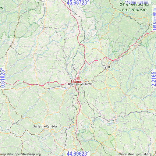
Ussac GPS coordinates[2]
45° 11' 38.004" North, 1° 30' 48.132" East
| Map corner | latitude | longitude |
|---|---|---|
| Upper-left | 45.68723°, | 0.81025° |
| Center: | 45.19389°, | 1.51337° |
| Lower-right: | 44.69623°, | 2.2165° |
| Map W x H: | 110.2×110.2 km | = 68.5×68.5mi |
| max Lat: | 51.07786° ⇑77.5% North |
| Ussac: | 45.19389° |
| min Lat: | ⇓22.5% South 41.3874° |
| min Long | Ussac | max Long |
| -5.08615° | 1.51337° | 9.52242° |
| W 37.1%⇐ | ⇒62.9% E |
Elevation
Elevation of Ussac is 207 m = 679 ft, and this is 13.3 m = 44 ft above average elevation for this country.
| Max E: |
2333 m = 7654 ft | 32.4% |
| Ussac | 207 m 679 ft | |
| Avg. | 193.7 m = 635 ft | |
Min E: |
-1 m = -3 ft | 67.6% |
See also: France elevation on elevation.city.
Geographical zone
Ussac is located in North temperate zone (between Tropic of Cancer and the Arctic Circle). Distance of this North polar circle is 2376.1 km =1476.4 mi to North.| Distance of | km | miles | from Ussac |
|---|---|---|---|
| North Pole | 4982 | 3095.7 | to North |
| Arctic Circle | 2376.1 | 1476.4 | to North |
| Tropic Cancer | 2419.2 | 1503.2 | to South |
| Equator | 5025.1 | 3122.5 | to South |


Nearby cities:
15 places around Ussac: (largest is in red/bold)
• Allassac
7.8 km =4.8 mi,  337°
337°
• Brive-la-Gaillarde
4.2 km =2.6 mi,  158°
158°
• Cosnac
8.7 km =5.4 mi,  139°
139°
• Dampniat
9.7 km =6 mi,  107°
107°
• Donzenac
3.8 km =2.4 mi,  12°
12°
• Lissac-sur-Couze
10.8 km =6.7 mi,  202°
202°
• Malemort-sur-Corrèze
4.7 km =2.9 mi,  122°
122°
• Mansac
10.6 km =6.6 mi,  254°
254°
• Noailles
10.1 km =6.3 mi,  175°
175°
• Sadroc
10.3 km =6.4 mi,  15°
15°
• Saint-Hilaire-Peyroux
10.8 km =6.7 mi,  78°
78°
• Saint-Pantaléon-de-Larche
7.9 km =4.9 mi,  221°
221°
• Saint-Viance
5.4 km =3.4 mi,  298°
298°
• Sainte-Féréole
6.7 km =4.2 mi,  53°
53°
• Varetz
4.9 km =3 mi,  270°
270°
Sources, notices
• [Note1] Compared only with cities in France existing in our database
• [Src1] Map data: © OpenStreetMap contributors (CC-BY-SA)
• [Src2] Other city data from geonames.org with taken over terms of usage.
• [Src3] Geographical zone / Annual Mean Temperature by Robert A. Rohde @ Wikipedia
