Neung-sur-Beuvron geodata
Neung-sur-Beuvron (Centre) is a populated place; located in France in Europe/Paris (GMT+2) time zone. With population of 1,152 people, there are 7813 cities with bigger population in this country. Compared to other cities in France, 51.7% of cities are located further ↓South; 59.4% of cities are located further →East and 61.2% of cities have higher elevation than Neung-sur-Beuvron. Note1
Administrative division(s):
- Level 1: Centre
- Level 2: Département du Loir-et-Cher
- Level 3: Arrondissement de Romorantin-Lanthenay
- Level 4: Neung-sur-Beuvron


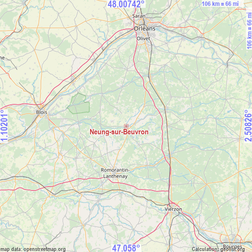
Neung-sur-Beuvron GPS coordinates[2]
47° 32' 5.496" North, 1° 48' 18.504" East
| Map corner | latitude | longitude |
|---|---|---|
| Upper-left | 48.00742°, | 1.10201° |
| Center: | 47.53486°, | 1.80514° |
| Lower-right: | 47.058°, | 2.50826° |
| Map W x H: | 105.6×105.6 km | = 65.6×65.6mi |
| max Lat: | 51.07786° ⇑48.3% North |
| Neung-sur-Beuvron: | 47.53486° |
| min Lat: | ⇓51.7% South 41.3874° |
| min Long | Neung-sur-Beuvr | max Long |
| -5.08615° | 1.80514° | 9.52242° |
| W 40.6%⇐ | ⇒59.4% E |
Elevation
Elevation of Neung-sur-Beuvron is 99 m = 325 ft, and this is 94.7 m = 311 ft below average elevation for this country.
| Max E: |
2333 m = 7654 ft | 61.2% |
| Avg. | 193.7 m = 635 ft | |
| Neung-sur-Beuvron | 99 m = 325 ft | |
Min E: |
-1 m = -3 ft | 38.8% |
See also: France elevation on elevation.city.
Geographical zone
Neung-sur-Beuvron is located in North temperate zone (between Tropic of Cancer and the Arctic Circle). Distance of this North polar circle is 2115.8 km =1314.7 mi to North.| Distance of | km | miles | from Neung-sur-Beuvron |
|---|---|---|---|
| North Pole | 4721.7 | 2933.9 | to North |
| Arctic Circle | 2115.8 | 1314.7 | to North |
| Tropic Cancer | 2679.5 | 1665 | to South |
| Equator | 5285.4 | 3284.2 | to South |


Nearby cities:
15 places around Neung-sur-Beuvron: (largest is in red/bold)
• Chaumont-sur-Tharonne
11.3 km =7 mi,  41°
41°
• Dhuizon
12.5 km =7.8 mi,  297°
297°
• La Ferté-Beauharnais
3.5 km =2.2 mi,  76°
76°
• La Ferté-Saint-Cyr
16.7 km =10.4 mi,  323°
323°
• Lamotte-Beuvron
18.3 km =11.4 mi,  65°
65°
• Ligny-le-Ribault
16.7 km =10.4 mi,  353°
353°
• Marcilly-en-Gault
9.3 km =5.8 mi,  145°
145°
• Millançay
10.1 km =6.3 mi,  194°
194°
• Montrieux-en-Sologne
6.3 km =3.9 mi,  289°
289°
• Nouan-le-Fuzelier
17.4 km =10.8 mi,  89°
89°
• Saint-Viâtre
9.7 km =6 mi,  96°
96°
• Selles-Saint-Denis
18.7 km =11.6 mi, 151°
• Vernou-en-Sologne
10.1 km =6.3 mi,  248°
248°
• Villeherviers
18.7 km =11.6 mi,  181°
181°
• Yvoy-le-Marron
11.4 km =7.1 mi,  18°
18°
Sources, notices
• [Note1] Compared only with cities in France existing in our database
• [Src1] Map data: © OpenStreetMap contributors (CC-BY-SA)
• [Src2] Other city data from geonames.org with taken over terms of usage.
• [Src3] Geographical zone / Annual Mean Temperature by Robert A. Rohde @ Wikipedia
