Ury geodata
Ury (Île-de-France) is a populated place; located in France in Europe/Paris (GMT+2) time zone. With population of 806 people, there are 10540 cities with bigger population in this country. Compared to other cities in France, 65.4% of cities are located further ↓South; 52.1% of cities are located further ←West and 54.8% of cities have higher elevation than Ury. Note1
Administrative division(s):
- Level 1: Île-de-France
- Level 2: Seine-et-Marne
- Level 3: Arrondissement de Fontainebleau
- Level 4: Ury


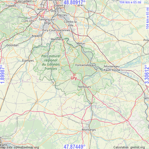
Ury GPS coordinates[2]
48° 20' 38.292" North, 2° 36' 10.764" East
| Map corner | latitude | longitude |
|---|---|---|
| Upper-left | 48.80917°, | 1.89987° |
| Center: | 48.34397°, | 2.60299° |
| Lower-right: | 47.87449°, | 3.30612° |
| Map W x H: | 103.9×103.9 km | = 64.6×64.6mi |
| max Lat: | 51.07786° ⇑34.6% North |
| Ury: | 48.34397° |
| min Lat: | ⇓65.4% South 41.3874° |
| min Long | Ury | max Long |
| -5.08615° | 2.60299° | 9.52242° |
| W 52.1%⇐ | ⇒47.9% E |
Elevation
Elevation of Ury is 117 m = 384 ft, and this is 76.7 m = 252 ft below average elevation for this country.
| Max E: |
2333 m = 7654 ft | 54.8% |
| Avg. | 193.7 m = 635 ft | |
| Ury | 117 m = 384 ft | |
Min E: |
-1 m = -3 ft | 45.2% |
See also: France elevation on elevation.city.
Geographical zone
Ury is located in North temperate zone (between Tropic of Cancer and the Arctic Circle). Distance of this North polar circle is 2025.8 km =1258.8 mi to North.| Distance of | km | miles | from Ury |
|---|---|---|---|
| North Pole | 4631.7 | 2878 | to North |
| Arctic Circle | 2025.8 | 1258.8 | to North |
| Tropic Cancer | 2769.4 | 1720.8 | to South |
| Equator | 5375.3 | 3340.1 | to South |


Nearby cities:
15 places around Ury: (largest is in red/bold)
• Achères-la-Forêt
2.7 km =1.7 mi,  296°
296°
• Arbonne-la-Forêt
8.2 km =5.1 mi,  341°
341°
• Bourron-Marlotte
7.2 km =4.5 mi,  93°
93°
• Fontainebleau
10.3 km =6.4 mi,  45°
45°
• Grez-sur-Loing
7 km =4.3 mi,  114°
114°
• La Chapelle-la-Reine
3.7 km =2.3 mi,  218°
218°
• Larchant
6.6 km =4.1 mi,  185°
185°
• Le Vaudoué
6.4 km =4 mi,  283°
283°
• Montcourt-Fromonville
8.6 km =5.3 mi,  118°
118°
• Montigny-sur-Loing
10.5 km =6.5 mi,  95°
95°
• Nemours
10 km =6.2 mi,  139°
139°
• Noisy-sur-École
7.5 km =4.7 mi,  290°
290°
• Recloses
3 km =1.9 mi,  84°
84°
• Saint-Pierre-lès-Nemours
10.2 km =6.3 mi,  146°
146°
• Villiers-sous-Grez
4.4 km =2.7 mi,  130°
130°
Sources, notices
• [Note1] Compared only with cities in France existing in our database
• [Src1] Map data: © OpenStreetMap contributors (CC-BY-SA)
• [Src2] Other city data from geonames.org with taken over terms of usage.
• [Src3] Geographical zone / Annual Mean Temperature by Robert A. Rohde @ Wikipedia
