Nogent-sur-Marne geodata
Nogent-sur-Marne (Île-de-France) is a seat of a third-order administrative division; located in France in Europe/Paris (GMT+2) time zone. With population of 31,236 people, there are 254 cities with bigger population in this country. Compared to other cities in France, 76.3% of cities are located further ↓South; 50.3% of cities are located further ←West and 72.6% of cities have higher elevation than Nogent-sur-Marne. Note1
Administrative division(s):
- Level 1: Île-de-France
- Level 2: Val-de-Marne
- Level 3: Arrondissement de Nogent-sur-Marne
- Level 4: Nogent-sur-Marne


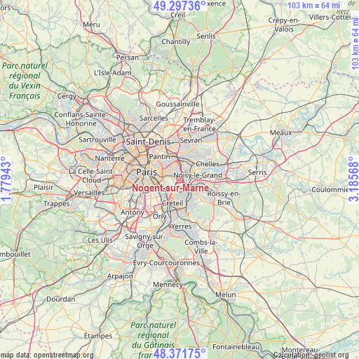
Nogent-sur-Marne GPS coordinates[2]
48° 50' 12.084" North, 2° 28' 57.18" East
| Map corner | latitude | longitude |
|---|---|---|
| Upper-left | 49.29736°, | 1.77943° |
| Center: | 48.83669°, | 2.48255° |
| Lower-right: | 48.37175°, | 3.18568° |
| Map W x H: | 102.9×102.9 km | = 63.9×63.9mi |
| max Lat: | 51.07786° ⇑23.7% North |
| Nogent-sur-Marne: | 48.83669° |
| min Lat: | ⇓76.3% South 41.3874° |
| min Long | Nogent-sur-Marn | max Long |
| -5.08615° | 2.48255° | 9.52242° |
| W 50.3%⇐ | ⇒49.7% E |
Elevation
Elevation of Nogent-sur-Marne is 72 m = 236 ft, and this is 121.7 m = 399 ft below average elevation for this country.
| Max E: |
2333 m = 7654 ft | 72.6% |
| Avg. | 193.7 m = 635 ft | |
| Nogent-sur-Marne | 72 m = 236 ft | |
Min E: |
-1 m = -3 ft | 27.4% |
See also: France elevation on elevation.city.
Geographical zone
Nogent-sur-Marne is located in North temperate zone (between Tropic of Cancer and the Arctic Circle). Distance of this North polar circle is 1971 km =1224.7 mi to North.| Distance of | km | miles | from Nogent-sur-Marne |
|---|---|---|---|
| North Pole | 4576.9 | 2844 | to North |
| Arctic Circle | 1971 | 1224.7 | to North |
| Tropic Cancer | 2824.2 | 1754.9 | to South |
| Equator | 5430.1 | 3374.1 | to South |


Nearby cities:
15 places around Nogent-sur-Marne: (largest is in red/bold)
• Bry-sur-Marne
3.1 km =1.9 mi,  87°
87°
• Champigny-sur-Marne
2.4 km =1.5 mi,  160°
160°
• Créteil
5 km =3.1 mi,  194°
194°
• Fontenay-sous-Bois
2 km =1.2 mi,  0°
0°
• Joinville-le-Pont
1.4 km =0.9 mi,  204°
204°
• Le Perreux-sur-Marne
2 km =1.2 mi,  40°
40°
• Maisons-Alfort
4.2 km =2.6 mi,  228°
228°
• Montreuil
4.2 km =2.6 mi,  316°
316°
• Neuilly-Plaisance
3.4 km =2.1 mi,  29°
29°
• Rosny-sous-Bois
3.9 km =2.4 mi,  18°
18°
• Saint-Mandé
4.9 km =3 mi,  272°
272°
• Saint-Maur-des-Fossés
4.8 km =3 mi,  170°
170°
• Saint-Maurice
4.4 km =2.7 mi,  247°
247°
• Villiers-sur-Marne
4.9 km =3 mi,  97°
97°
• Vincennes
3.5 km =2.2 mi,  291°
291°
Sources, notices
• [Note1] Compared only with cities in France existing in our database
• [Src1] Map data: © OpenStreetMap contributors (CC-BY-SA)
• [Src2] Other city data from geonames.org with taken over terms of usage.
• [Src3] Geographical zone / Annual Mean Temperature by Robert A. Rohde @ Wikipedia
