Bois-Grenier geodata
Bois-Grenier (Hauts-de-France) is a populated place; located in France in Europe/Paris (GMT+2) time zone. With population of 1,491 people, there are 6225 cities with bigger population in this country. Compared to other cities in France, 98.4% of cities are located further ↓South; 56.1% of cities are located further ←West and 94.4% of cities have higher elevation than Bois-Grenier. Note1
Administrative division(s):
- Level 1: Hauts-de-France
- Level 2: Nord
- Level 3: Arrondissement de Lille
- Level 4: Bois-Grenier


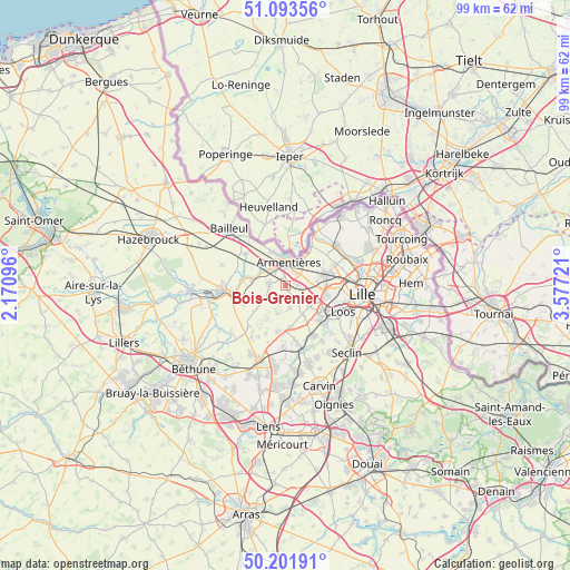
Bois-Grenier GPS coordinates[2]
50° 38' 59.46" North, 2° 52' 26.724" East
| Map corner | latitude | longitude |
|---|---|---|
| Upper-left | 51.09356°, | 2.17096° |
| Center: | 50.64985°, | 2.87409° |
| Lower-right: | 50.20191°, | 3.57721° |
| Map W x H: | 99.1×99.1 km | = 61.6×61.6mi |
| max Lat: | 51.07786° ⇑1.6% North |
| Bois-Grenier: | 50.64985° |
| min Lat: | ⇓98.4% South 41.3874° |
| min Long | Bois-Grenier | max Long |
| -5.08615° | 2.87409° | 9.52242° |
| W 56.1%⇐ | ⇒43.9% E |
Elevation
Elevation of Bois-Grenier is 19 m = 62 ft, and this is 174.7 m = 573 ft below average elevation for this country.
| Max E: |
2333 m = 7654 ft | 94.4% |
| Avg. | 193.7 m = 635 ft | |
| Bois-Grenier | 19 m = 62 ft | |
Min E: |
-1 m = -3 ft | 5.6% |
See also: France elevation on elevation.city.
Geographical zone
Bois-Grenier is located in North temperate zone (between Tropic of Cancer and the Arctic Circle). Distance of this North polar circle is 1769.4 km =1099.5 mi to North.| Distance of | km | miles | from Bois-Grenier |
|---|---|---|---|
| North Pole | 4375.3 | 2718.7 | to North |
| Arctic Circle | 1769.4 | 1099.5 | to North |
| Tropic Cancer | 3025.8 | 1880.1 | to South |
| Equator | 5631.7 | 3499.4 | to South |


Nearby cities:
15 places around Bois-Grenier: (largest is in red/bold)
• Armentières
4 km =2.5 mi,  8°
8°
• Aubers
6.9 km =4.3 mi,  208°
208°
• Beaucamps-Ligny
5.7 km =3.5 mi,  149°
149°
• Capinghem
6.2 km =3.9 mi,  94°
94°
• Englos
6.4 km =4 mi,  113°
113°
• Ennetières-en-Weppes
4.9 km =3 mi, 109°
• Erquinghem-Lys
3.6 km =2.2 mi,  324°
324°
• Fleurbaix
2.9 km =1.8 mi,  271°
271°
• Fromelles
5 km =3.1 mi,  197°
197°
• Houplines
5.8 km =3.6 mi,  29°
29°
• Le Maisnil
3.9 km =2.4 mi,  168°
168°
• Nieppe
6.6 km =4.1 mi,  335°
335°
• Prémesques
5.5 km =3.4 mi,  83°
83°
• Pérenchies
7.1 km =4.4 mi,  71°
71°
• Radinghem-en-Weppes
4.2 km =2.6 mi,  144°
144°
Sources, notices
• [Note1] Compared only with cities in France existing in our database
• [Src1] Map data: © OpenStreetMap contributors (CC-BY-SA)
• [Src2] Other city data from geonames.org with taken over terms of usage.
• [Src3] Geographical zone / Annual Mean Temperature by Robert A. Rohde @ Wikipedia
