Nangis geodata
Nangis (Île-de-France) is a populated place; located in France in Europe/Paris (GMT+2) time zone. With population of 8,271 people, there are 1174 cities with bigger population in this country. Compared to other cities in France, 69.7% of cities are located further ↓South; 58% of cities are located further ←West and 50.9% of cities have higher elevation than Nangis. Note1
Administrative division(s):
- Level 1: Île-de-France
- Level 2: Seine-et-Marne
- Level 3: Arrondissement de Provins
- Level 4: Nangis


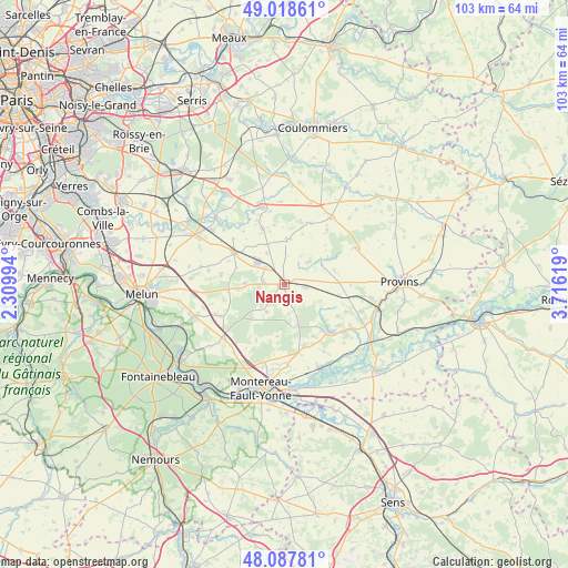
Nangis GPS coordinates[2]
48° 33' 19.26" North, 3° 0' 47.016" East
| Map corner | latitude | longitude |
|---|---|---|
| Upper-left | 49.01861°, | 2.30994° |
| Center: | 48.55535°, | 3.01306° |
| Lower-right: | 48.08781°, | 3.71619° |
| Map W x H: | 103.5×103.5 km | = 64.3×64.3mi |
| max Lat: | 51.07786° ⇑30.3% North |
| Nangis: | 48.55535° |
| min Lat: | ⇓69.7% South 41.3874° |
| min Long | Nangis | max Long |
| -5.08615° | 3.01306° | 9.52242° |
| W 58%⇐ | ⇒42% E |
Elevation
Elevation of Nangis is 129 m = 423 ft, and this is 64.7 m = 212 ft below average elevation for this country.
| Max E: |
2333 m = 7654 ft | 50.9% |
| Avg. | 193.7 m = 635 ft | |
| Nangis | 129 m = 423 ft | |
Min E: |
-1 m = -3 ft | 49.1% |
See also: France elevation on elevation.city.
Geographical zone
Nangis is located in North temperate zone (between Tropic of Cancer and the Arctic Circle). Distance of this North polar circle is 2002.3 km =1244.2 mi to North.| Distance of | km | miles | from Nangis |
|---|---|---|---|
| North Pole | 4608.2 | 2863.4 | to North |
| Arctic Circle | 2002.3 | 1244.2 | to North |
| Tropic Cancer | 2792.9 | 1735.4 | to South |
| Equator | 5398.8 | 3354.7 | to South |


Nearby cities:
15 places around Nangis: (largest is in red/bold)
• Bailly-Carrois
3.2 km =2 mi,  329°
329°
• Bombon
11.4 km =7.1 mi,  279°
279°
• Courpalay
11.1 km =6.9 mi,  339°
339°
• Fontenailles
4.5 km =2.8 mi,  265°
265°
• Gastins
8.2 km =5.1 mi,  3°
3°
• La Chapelle-Gauthier
8.5 km =5.3 mi, 265°
• La Chapelle-Rablais
5.8 km =3.6 mi,  211°
211°
• La Croix-en-Brie
6.3 km =3.9 mi,  47°
47°
• Mormant
10.8 km =6.7 mi,  303°
303°
• Pécy
12.2 km =7.6 mi,  24°
24°
• Quiers
6.6 km =4.1 mi, 330°
• Rampillon
4 km =2.5 mi,  97°
97°
• Saint-Ouen-en-Brie
6.9 km =4.3 mi, 272°
• Villeneuve-les-Bordes
8.5 km =5.3 mi,  161°
161°
• Échouboulains
11.3 km =7 mi, 206°
Sources, notices
• [Note1] Compared only with cities in France existing in our database
• [Src1] Map data: © OpenStreetMap contributors (CC-BY-SA)
• [Src2] Other city data from geonames.org with taken over terms of usage.
• [Src3] Geographical zone / Annual Mean Temperature by Robert A. Rohde @ Wikipedia
