La Chapelle-Gauthier geodata
La Chapelle-Gauthier (Île-de-France) is a populated place; located in France in Europe/Paris (GMT+2) time zone. With population of 1,358 people, there are 6774 cities with bigger population in this country. Compared to other cities in France, 69.5% of cities are located further ↓South; 56.4% of cities are located further ←West and 59.1% of cities have higher elevation than La Chapelle-Gauthier. Note1
Administrative division(s):
- Level 1: Île-de-France
- Level 2: Seine-et-Marne
- Level 3: Arrondissement de Provins
- Level 4: La Chapelle-Gauthier


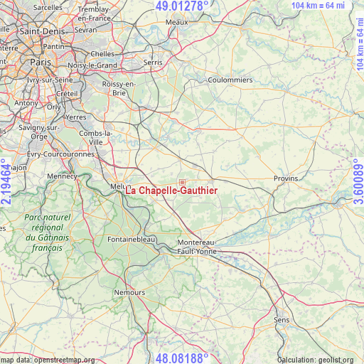
La Chapelle-Gauthier GPS coordinates[2]
48° 32' 58.092" North, 2° 53' 51.936" East
| Map corner | latitude | longitude |
|---|---|---|
| Upper-left | 49.01278°, | 2.19464° |
| Center: | 48.54947°, | 2.89776° |
| Lower-right: | 48.08188°, | 3.60089° |
| Map W x H: | 103.5×103.5 km | = 64.3×64.3mi |
| max Lat: | 51.07786° ⇑30.5% North |
| La Chapelle-Gauthier: | 48.54947° |
| min Lat: | ⇓69.5% South 41.3874° |
| min Long | La Chapelle-Gau | max Long |
| -5.08615° | 2.89776° | 9.52242° |
| W 56.4%⇐ | ⇒43.6% E |
Elevation
Elevation of La Chapelle-Gauthier is 105 m = 344 ft, and this is 88.7 m = 291 ft below average elevation for this country.
| Max E: |
2333 m = 7654 ft | 59.1% |
| Avg. | 193.7 m = 635 ft | |
| La Chapelle-Gauthier | 105 m = 344 ft | |
Min E: |
-1 m = -3 ft | 40.9% |
See also: France elevation on elevation.city.
Geographical zone
La Chapelle-Gauthier is located in North temperate zone (between Tropic of Cancer and the Arctic Circle). Distance of this North polar circle is 2003 km =1244.6 mi to North.| Distance of | km | miles | from La Chapelle-Gauthier |
|---|---|---|---|
| North Pole | 4608.9 | 2863.8 | to North |
| Arctic Circle | 2003 | 1244.6 | to North |
| Tropic Cancer | 2792.3 | 1735.1 | to South |
| Equator | 5398.2 | 3354.3 | to South |


Nearby cities:
15 places around La Chapelle-Gauthier: (largest is in red/bold)
• Aubepierre-Ozouer-le-Repos
9.4 km =5.8 mi,  353°
353°
• Bailly-Carrois
7.6 km =4.7 mi,  63°
63°
• Blandy
8.8 km =5.5 mi,  282°
282°
• Bombon
3.7 km =2.3 mi,  312°
312°
• Champeaux
7.8 km =4.8 mi,  300°
300°
• Fontenailles
4 km =2.5 mi,  85°
85°
• Fouju
9.7 km =6 mi,  294°
294°
• La Chapelle-Rablais
6.9 km =4.3 mi,  127°
127°
• Le Châtelet-en-Brie
9.1 km =5.7 mi,  238°
238°
• Les Écrennes
5.8 km =3.6 mi,  210°
210°
• Mormant
6.6 km =4.1 mi,  355°
355°
• Nangis
8.5 km =5.3 mi, 85°
• Pamfou
10 km =6.2 mi,  191°
191°
• Quiers
8.3 km =5.2 mi,  39°
39°
• Saint-Ouen-en-Brie
1.9 km =1.2 mi, 58°
Sources, notices
• [Note1] Compared only with cities in France existing in our database
• [Src1] Map data: © OpenStreetMap contributors (CC-BY-SA)
• [Src2] Other city data from geonames.org with taken over terms of usage.
• [Src3] Geographical zone / Annual Mean Temperature by Robert A. Rohde @ Wikipedia
