Mormant geodata
Mormant (Île-de-France) is a populated place; located in France in Europe/Paris (GMT+2) time zone. With population of 4,765 people, there are 2083 cities with bigger population in this country. Compared to other cities in France, 71.1% of cities are located further ↓South; 56.3% of cities are located further ←West and 57.3% of cities have higher elevation than Mormant. Note1
Administrative division(s):
- Level 1: Île-de-France
- Level 2: Seine-et-Marne
- Level 3: Arrondissement de Provins
- Level 4: Mormant


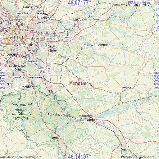
Mormant GPS coordinates[2]
48° 36' 32.436" North, 2° 53' 24.9" East
| Map corner | latitude | longitude |
|---|---|---|
| Upper-left | 49.07177°, | 2.18713° |
| Center: | 48.60901°, | 2.89025° |
| Lower-right: | 48.14197°, | 3.59338° |
| Map W x H: | 103.4×103.4 km | = 64.2×64.2mi |
| max Lat: | 51.07786° ⇑28.9% North |
| Mormant: | 48.60901° |
| min Lat: | ⇓71.1% South 41.3874° |
| min Long | Mormant | max Long |
| -5.08615° | 2.89025° | 9.52242° |
| W 56.3%⇐ | ⇒43.7% E |
Elevation
Elevation of Mormant is 110 m = 361 ft, and this is 83.7 m = 275 ft below average elevation for this country.
| Max E: |
2333 m = 7654 ft | 57.3% |
| Avg. | 193.7 m = 635 ft | |
| Mormant | 110 m = 361 ft | |
Min E: |
-1 m = -3 ft | 42.7% |
See also: France elevation on elevation.city.
Geographical zone
Mormant is located in North temperate zone (between Tropic of Cancer and the Arctic Circle). Distance of this North polar circle is 1996.4 km =1240.5 mi to North.| Distance of | km | miles | from Mormant |
|---|---|---|---|
| North Pole | 4602.2 | 2859.7 | to North |
| Arctic Circle | 1996.4 | 1240.5 | to North |
| Tropic Cancer | 2798.9 | 1739.2 | to South |
| Equator | 5404.8 | 3358.4 | to South |


Nearby cities:
15 places around Mormant: (largest is in red/bold)
• Aubepierre-Ozouer-le-Repos
2.8 km =1.7 mi,  349°
349°
• Bailly-Carrois
8 km =5 mi,  113°
113°
• Bernay-Vilbert
8.3 km =5.2 mi,  24°
24°
• Blandy
9.2 km =5.7 mi,  239°
239°
• Bombon
4.7 km =2.9 mi,  207°
207°
• Champeaux
6.7 km =4.2 mi,  246°
246°
• Chaumes-en-Brie
7.6 km =4.7 mi,  330°
330°
• Courpalay
6.9 km =4.3 mi,  49°
49°
• Courtomer
5 km =3.1 mi,  12°
12°
• Fontenailles
7.8 km =4.8 mi,  144°
144°
• Fouju
8.7 km =5.4 mi, 252°
• Guignes
7.2 km =4.5 mi,  292°
292°
• La Chapelle-Gauthier
6.6 km =4.1 mi,  175°
175°
• Quiers
5.8 km =3.6 mi,  92°
92°
• Saint-Ouen-en-Brie
6 km =3.7 mi,  159°
159°
Sources, notices
• [Note1] Compared only with cities in France existing in our database
• [Src1] Map data: © OpenStreetMap contributors (CC-BY-SA)
• [Src2] Other city data from geonames.org with taken over terms of usage.
• [Src3] Geographical zone / Annual Mean Temperature by Robert A. Rohde @ Wikipedia
