Échouboulains geodata
Échouboulains (Île-de-France) is a populated place; located in France in Europe/Paris (GMT+2) time zone. With population of 540 people, there are 14387 cities with bigger population in this country. Compared to other cities in France, 67.5% of cities are located further ↓South; 57% of cities are located further ←West and 54.1% of cities have higher elevation than Échouboulains. Note1
Administrative division(s):
- Level 1: Île-de-France
- Level 2: Seine-et-Marne
- Level 3: Arrondissement de Melun
- Level 4: Échouboulains


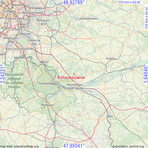
Échouboulains GPS coordinates[2]
48° 27' 49.644" North, 2° 56' 43.224" East
| Map corner | latitude | longitude |
|---|---|---|
| Upper-left | 48.92789°, | 2.24221° |
| Center: | 48.46379°, | 2.94534° |
| Lower-right: | 47.99541°, | 3.64846° |
| Map W x H: | 103.7×103.7 km | = 64.4×64.4mi |
| max Lat: | 51.07786° ⇑32.5% North |
| Échouboulains: | 48.46379° |
| min Lat: | ⇓67.5% South 41.3874° |
| min Long | Échouboulains | max Long |
| -5.08615° | 2.94534° | 9.52242° |
| W 57%⇐ | ⇒43% E |
Elevation
Elevation of Échouboulains is 119 m = 390 ft, and this is 74.7 m = 245 ft below average elevation for this country.
| Max E: |
2333 m = 7654 ft | 54.1% |
| Avg. | 193.7 m = 635 ft | |
| Échouboulains | 119 m = 390 ft | |
Min E: |
-1 m = -3 ft | 45.9% |
See also: France elevation on elevation.city.
Geographical zone
Échouboulains is located in North temperate zone (between Tropic of Cancer and the Arctic Circle). Distance of this North polar circle is 2012.5 km =1250.5 mi to North.| Distance of | km | miles | from Échouboulains |
|---|---|---|---|
| North Pole | 4618.4 | 2869.7 | to North |
| Arctic Circle | 2012.5 | 1250.5 | to North |
| Tropic Cancer | 2782.7 | 1729.1 | to South |
| Equator | 5388.7 | 3348.4 | to South |


Nearby cities:
15 places around Échouboulains: (largest is in red/bold)
• Fontenailles
9.8 km =6.1 mi,  2°
2°
• Féricy
10.7 km =6.6 mi,  267°
267°
• La Chapelle-Gauthier
10.2 km =6.3 mi,  339°
339°
• La Chapelle-Rablais
5.6 km =3.5 mi,  20°
20°
• La Grande-Paroisse
9.1 km =5.7 mi,  200°
200°
• Les Écrennes
7.9 km =4.9 mi,  305°
305°
• Machault
8.5 km =5.3 mi,  263°
263°
• Montereau-Fault-Yonne
9 km =5.6 mi,  177°
177°
• Montigny-Lencoup
8.9 km =5.5 mi,  98°
98°
• Pamfou
5.6 km =3.5 mi, 266°
• Saint-Germain-Laval
8.1 km =5 mi,  151°
151°
• Salins
7.3 km =4.5 mi,  129°
129°
• Valence-en-Brie
4.7 km =2.9 mi,  240°
240°
• Varennes-sur-Seine
10.2 km =6.3 mi,  188°
188°
• Villeneuve-les-Bordes
7.9 km =4.9 mi,  74°
74°
Sources, notices
• [Note1] Compared only with cities in France existing in our database
• [Src1] Map data: © OpenStreetMap contributors (CC-BY-SA)
• [Src2] Other city data from geonames.org with taken over terms of usage.
• [Src3] Geographical zone / Annual Mean Temperature by Robert A. Rohde @ Wikipedia
