Saint-Simon geodata
Saint-Simon (Hauts-de-France) is a populated place; located in France in Europe/Paris (GMT+2) time zone. With population of 658 people, there are 12412 cities with bigger population in this country. Compared to other cities in France, 91.9% of cities are located further ↓South; 60.2% of cities are located further ←West and 75% of cities have higher elevation than Saint-Simon. Note1
Administrative division(s):
- Level 1: Hauts-de-France
- Level 2: Département de l'Aisne
- Level 3: Arrondissement de Saint-Quentin
- Level 4: Saint-Simon


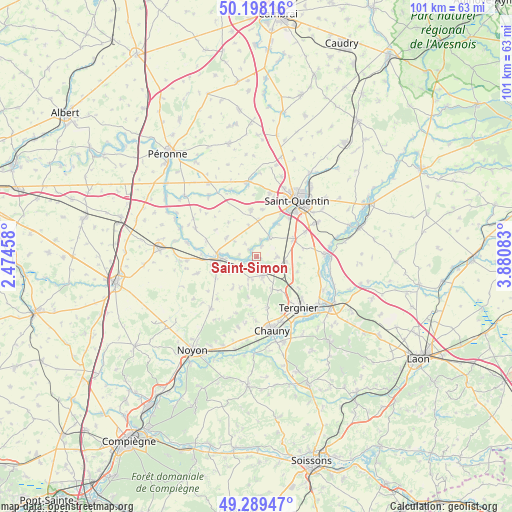
Saint-Simon GPS coordinates[2]
49° 44' 45.384" North, 3° 10' 39.756" East
| Map corner | latitude | longitude |
|---|---|---|
| Upper-left | 50.19816°, | 2.47458° |
| Center: | 49.74594°, | 3.17771° |
| Lower-right: | 49.28947°, | 3.88083° |
| Map W x H: | 101×101 km | = 62.8×62.8mi |
| max Lat: | 51.07786° ⇑8.1% North |
| Saint-Simon: | 49.74594° |
| min Lat: | ⇓91.9% South 41.3874° |
| min Long | Saint-Simon | max Long |
| -5.08615° | 3.17771° | 9.52242° |
| W 60.2%⇐ | ⇒39.8% E |
Elevation
Elevation of Saint-Simon is 67 m = 220 ft, and this is 126.7 m = 416 ft below average elevation for this country.
| Max E: |
2333 m = 7654 ft | 75% |
| Avg. | 193.7 m = 635 ft | |
| Saint-Simon | 67 m = 220 ft | |
Min E: |
-1 m = -3 ft | 25% |
See also: France elevation on elevation.city.
Geographical zone
Saint-Simon is located in North temperate zone (between Tropic of Cancer and the Arctic Circle). Distance of this North polar circle is 1869.9 km =1161.9 mi to North.| Distance of | km | miles | from Saint-Simon |
|---|---|---|---|
| North Pole | 4475.8 | 2781.1 | to North |
| Arctic Circle | 1869.9 | 1161.9 | to North |
| Tropic Cancer | 2925.3 | 1817.7 | to South |
| Equator | 5531.2 | 3436.9 | to South |


Nearby cities:
15 places around Saint-Simon: (largest is in red/bold)
• Brouchy
6.5 km =4 mi,  239°
239°
• Clastres
4 km =2.5 mi,  89°
89°
• Cugny
4.6 km =2.9 mi,  202°
202°
• Eppeville
9.1 km =5.7 mi,  266°
266°
• Essigny-le-Grand
8.1 km =5 mi,  63°
63°
• Flavy-le-Martel
3.8 km =2.4 mi,  164°
164°
• Frières-Faillouël
8 km =5 mi,  143°
143°
• Grugies
9.8 km =6.1 mi,  41°
41°
• Ham
7.5 km =4.7 mi, 271°
• Jussy
4.9 km =3 mi,  126°
126°
• Montescourt-Lizerolles
5.8 km =3.6 mi,  98°
98°
• Muille-Villette
8.2 km =5.1 mi,  255°
255°
• Savy
9.5 km =5.9 mi,  7°
7°
• Seraucourt-le-Grand
5 km =3.1 mi,  33°
33°
• Étreillers
9.5 km =5.9 mi,  352°
352°
Sources, notices
• [Note1] Compared only with cities in France existing in our database
• [Src1] Map data: © OpenStreetMap contributors (CC-BY-SA)
• [Src2] Other city data from geonames.org with taken over terms of usage.
• [Src3] Geographical zone / Annual Mean Temperature by Robert A. Rohde @ Wikipedia
