Mortrée geodata
Mortrée (Normandy) is a populated place; located in France in Europe/Paris (GMT+2) time zone. With population of 1,091 people, there are 8187 cities with bigger population in this country. Compared to other cities in France, 71.8% of cities are located further ↓South; 77.4% of cities are located further →East and 61.3% of cities have lower elevation than Mortrée. Note1
Administrative division(s):
- Level 1: Normandy
- Level 2: Département de l'Orne
- Level 3: Arrondissement d’Alençon
- Level 4: Mortrée


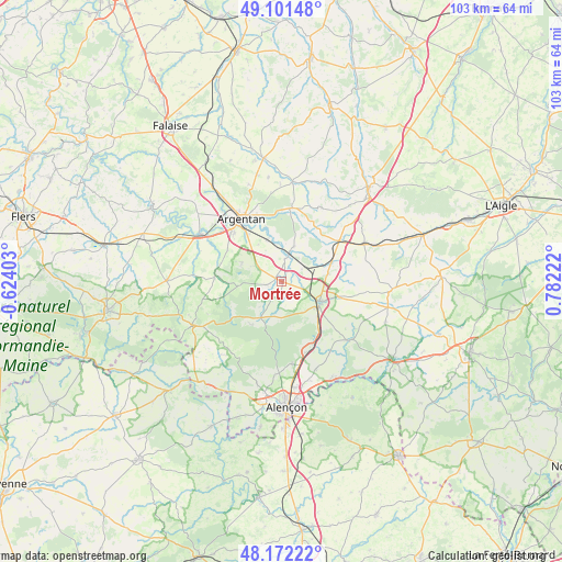
Mortrée GPS coordinates[2]
48° 38' 20.364" North, 0° 4' 44.724" East
| Map corner | latitude | longitude |
|---|---|---|
| Upper-left | 49.10148°, | -0.62403° |
| Center: | 48.63899°, | 0.07909° |
| Lower-right: | 48.17222°, | 0.78222° |
| Map W x H: | 103.3×103.3 km | = 64.2×64.2mi |
| max Lat: | 51.07786° ⇑28.2% North |
| Mortrée: | 48.63899° |
| min Lat: | ⇓71.8% South 41.3874° |
| min Long | Mortrée | max Long |
| -5.08615° | 0.07909° | 9.52242° |
| W 22.6%⇐ | ⇒77.4% E |
Elevation
Elevation of Mortrée is 176 m = 577 ft, and this is 17.7 m = 58 ft below average elevation for this country.
| Max E: |
2333 m = 7654 ft | 38.7% |
| Avg. | 193.7 m = 635 ft | |
| Mortrée | 176 m = 577 ft | |
Min E: |
-1 m = -3 ft | 61.3% |
See also: France elevation on elevation.city.
Geographical zone
Mortrée is located in North temperate zone (between Tropic of Cancer and the Arctic Circle). Distance of this North polar circle is 1993 km =1238.4 mi to North.| Distance of | km | miles | from Mortrée |
|---|---|---|---|
| North Pole | 4598.9 | 2857.6 | to North |
| Arctic Circle | 1993 | 1238.4 | to North |
| Tropic Cancer | 2802.2 | 1741.2 | to South |
| Equator | 5408.1 | 3360.4 | to South |


Nearby cities:
15 places around Mortrée: (largest is in red/bold)
• Almenêches
6.8 km =4.2 mi,  19°
19°
• Argentan
13.8 km =8.6 mi,  328°
328°
• Bailleul
18.9 km =11.7 mi,  341°
341°
• Boucé
12.5 km =7.8 mi,  273°
273°
• Carrouges
18.3 km =11.4 mi,  244°
244°
• Essay
16.4 km =10.2 mi,  131°
131°
• Le Merlerault
16.6 km =10.3 mi,  65°
65°
• Nonant-le-Pin
12.8 km =8 mi,  54°
54°
• Occagnes
19.2 km =11.9 mi,  324°
324°
• Radon
15.3 km =9.5 mi,  173°
173°
• Sarceaux
12.5 km =7.8 mi, 315°
• Sées
7.9 km =4.9 mi,  119°
119°
• Urou-et-Crennes
13.5 km =8.4 mi, 340°
• Valframbert
19.5 km =12.1 mi, 173°
• Écouché
17.3 km =10.7 mi,  300°
300°
Sources, notices
• [Note1] Compared only with cities in France existing in our database
• [Src1] Map data: © OpenStreetMap contributors (CC-BY-SA)
• [Src2] Other city data from geonames.org with taken over terms of usage.
• [Src3] Geographical zone / Annual Mean Temperature by Robert A. Rohde @ Wikipedia
