Urou-et-Crennes geodata
Urou-et-Crennes (Normandy) is a populated place; located in France in Europe/Paris (GMT+2) time zone. With population of 669 people, there are 12229 cities with bigger population in this country. Compared to other cities in France, 74.4% of cities are located further ↓South; 78% of cities are located further →East and 60.7% of cities have lower elevation than Urou-et-Crennes. Note1
Administrative division(s):
- Level 1: Normandy
- Level 2: Département de l'Orne
- Level 3: Argentan
- Level 4: Gouffern en Auge


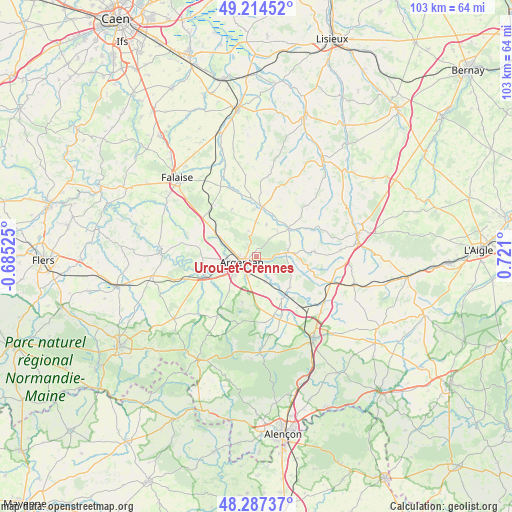
Urou-et-Crennes GPS coordinates[2]
48° 45' 11.088" North, 0° 1' 4.368" East
| Map corner | latitude | longitude |
|---|---|---|
| Upper-left | 49.21452°, | -0.68525° |
| Center: | 48.75308°, | 0.01788° |
| Lower-right: | 48.28737°, | 0.721° |
| Map W x H: | 103.1×103.1 km | = 64.1×64.1mi |
| max Lat: | 51.07786° ⇑25.6% North |
| Urou-et-Crennes: | 48.75308° |
| min Lat: | ⇓74.4% South 41.3874° |
| min Long | Urou-et-Crennes | max Long |
| -5.08615° | 0.01788° | 9.52242° |
| W 22%⇐ | ⇒78% E |
Elevation
Elevation of Urou-et-Crennes is 173 m = 568 ft, and this is 20.7 m = 68 ft below average elevation for this country.
| Max E: |
2333 m = 7654 ft | 39.3% |
| Avg. | 193.7 m = 635 ft | |
| Urou-et-Crennes | 173 m = 568 ft | |
Min E: |
-1 m = -3 ft | 60.7% |
See also: France elevation on elevation.city.
Geographical zone
Urou-et-Crennes is located in North temperate zone (between Tropic of Cancer and the Arctic Circle). Distance of this North polar circle is 1980.3 km =1230.5 mi to North.| Distance of | km | miles | from Urou-et-Crennes |
|---|---|---|---|
| North Pole | 4586.2 | 2849.7 | to North |
| Arctic Circle | 1980.3 | 1230.5 | to North |
| Tropic Cancer | 2814.9 | 1749.1 | to South |
| Equator | 5420.8 | 3368.3 | to South |


Nearby cities:
15 places around Urou-et-Crennes: (largest is in red/bold)
• Almenêches
9.2 km =5.7 mi,  132°
132°
• Argentan
3 km =1.9 mi,  250°
250°
• Bailleul
5.5 km =3.4 mi,  343°
343°
• Boucé
14.3 km =8.9 mi,  213°
213°
• Courteilles
16.1 km =10 mi,  278°
278°
• La Hoguette
19 km =11.8 mi,  316°
316°
• Mortrée
13.5 km =8.4 mi,  160°
160°
• Nonant-le-Pin
15.7 km =9.8 mi,  109°
109°
• Occagnes
7.2 km =4.5 mi,  294°
294°
• Pont-Écrepin
19.3 km =12 mi,  273°
273°
• Putanges-Pont-Écrepin
19.7 km =12.2 mi, 274°
• Sarceaux
5.7 km =3.5 mi,  228°
228°
• Sées
20.1 km =12.5 mi,  145°
145°
• Trun
10 km =6.2 mi,  6°
6°
• Écouché
11.1 km =6.9 mi, 249°
Sources, notices
• [Note1] Compared only with cities in France existing in our database
• [Src1] Map data: © OpenStreetMap contributors (CC-BY-SA)
• [Src2] Other city data from geonames.org with taken over terms of usage.
• [Src3] Geographical zone / Annual Mean Temperature by Robert A. Rohde @ Wikipedia
