Nonant-le-Pin geodata
Nonant-le-Pin (Normandy) is a populated place; located in France in Europe/Paris (GMT+2) time zone. With population of 668 people, there are 12251 cities with bigger population in this country. Compared to other cities in France, 73.4% of cities are located further ↓South; 76.1% of cities are located further →East and 64.2% of cities have lower elevation than Nonant-le-Pin. Note1
Administrative division(s):
- Level 1: Normandy
- Level 2: Département de l'Orne
- Level 3: Arrondissement de Mortagne-au-Perche
- Level 4: Nonant-le-Pin


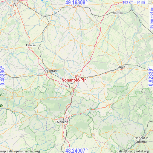
Nonant-le-Pin GPS coordinates[2]
48° 42' 22.392" North, 0° 13' 12.936" East
| Map corner | latitude | longitude |
|---|---|---|
| Upper-left | 49.16809°, | -0.48286° |
| Center: | 48.70622°, | 0.22026° |
| Lower-right: | 48.24007°, | 0.92339° |
| Map W x H: | 103.2×103.2 km | = 64.1×64.1mi |
| max Lat: | 51.07786° ⇑26.6% North |
| Nonant-le-Pin: | 48.70622° |
| min Lat: | ⇓73.4% South 41.3874° |
| min Long | Nonant-le-Pin | max Long |
| -5.08615° | 0.22026° | 9.52242° |
| W 23.9%⇐ | ⇒76.1% E |
Elevation
Elevation of Nonant-le-Pin is 190 m = 623 ft, and this is 3.7 m = 12 ft below average elevation for this country.
| Max E: |
2333 m = 7654 ft | 35.8% |
| Avg. | 193.7 m = 635 ft | |
| Nonant-le-Pin | 190 m = 623 ft | |
Min E: |
-1 m = -3 ft | 64.2% |
See also: France elevation on elevation.city.
Geographical zone
Nonant-le-Pin is located in North temperate zone (between Tropic of Cancer and the Arctic Circle). Distance of this North polar circle is 1985.6 km =1233.8 mi to North.| Distance of | km | miles | from Nonant-le-Pin |
|---|---|---|---|
| North Pole | 4591.4 | 2853 | to North |
| Arctic Circle | 1985.6 | 1233.8 | to North |
| Tropic Cancer | 2809.7 | 1745.9 | to South |
| Equator | 5415.6 | 3365.1 | to South |


Nearby cities:
15 places around Nonant-le-Pin: (largest is in red/bold)
• Almenêches
8.1 km =5 mi,  262°
262°
• Argentan
18.1 km =11.2 mi,  283°
283°
• Bailleul
19.4 km =12.1 mi,  302°
302°
• Courtomer
13.3 km =8.3 mi,  131°
131°
• Essay
18.4 km =11.4 mi,  173°
173°
• Gacé
11.2 km =7 mi,  29°
29°
• Le Merlerault
4.8 km =3 mi,  97°
97°
• Mortrée
12.8 km =8 mi,  234°
234°
• Moulins-la-Marche
19.7 km =12.2 mi,  108°
108°
• Sainte-Gauburge-Sainte-Colombe
15.5 km =9.6 mi,  85°
85°
• Sainte-Scolasse-sur-Sarthe
19.2 km =11.9 mi,  138°
138°
• Sarceaux
19.2 km =11.9 mi,  274°
274°
• Sées
11.9 km =7.4 mi,  197°
197°
• Urou-et-Crennes
15.7 km =9.8 mi,  289°
289°
• Échauffour
12.9 km =8 mi,  72°
72°
Sources, notices
• [Note1] Compared only with cities in France existing in our database
• [Src1] Map data: © OpenStreetMap contributors (CC-BY-SA)
• [Src2] Other city data from geonames.org with taken over terms of usage.
• [Src3] Geographical zone / Annual Mean Temperature by Robert A. Rohde @ Wikipedia
