Épargnes geodata
Épargnes (Nouvelle-Aquitaine) is a populated place; located in France in Europe/Paris (GMT+2) time zone. With population of 785 people, there are 10762 cities with bigger population in this country. Compared to other cities in France, 73.6% of cities are located further ↑North; 86.5% of cities are located further →East and 79% of cities have higher elevation than Épargnes. Note1
Administrative division(s):
- Level 1: Nouvelle-Aquitaine
- Level 2: Charente-Maritime
- Level 3: Arrondissement de Saintes
- Level 4: Épargnes


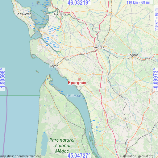
Épargnes GPS coordinates[2]
45° 32' 30.804" North, 0° 48' 10.26" West
| Map corner | latitude | longitude |
|---|---|---|
| Upper-left | 46.03219°, | -1.50598° |
| Center: | 45.54189°, | -0.80285° |
| Lower-right: | 45.04727°, | -0.09973° |
| Map W x H: | 109.5×109.5 km | = 68×68mi |
| max Lat: | 51.07786° ⇑73.6% North |
| Épargnes: | 45.54189° |
| min Lat: | ⇓26.4% South 41.3874° |
| min Long | Épargnes | max Long |
| -5.08615° | -0.80285° | 9.52242° |
| W 13.5%⇐ | ⇒86.5% E |
Elevation
Elevation of Épargnes is 57 m = 187 ft, and this is 136.7 m = 448 ft below average elevation for this country.
| Max E: |
2333 m = 7654 ft | 79% |
| Avg. | 193.7 m = 635 ft | |
| Épargnes | 57 m = 187 ft | |
Min E: |
-1 m = -3 ft | 21% |
See also: France elevation on elevation.city.
Geographical zone
Épargnes is located in North temperate zone (between Tropic of Cancer and the Arctic Circle). Distance of this North polar circle is 2337.4 km =1452.4 mi to North.| Distance of | km | miles | from Épargnes |
|---|---|---|---|
| North Pole | 4943.3 | 3071.6 | to North |
| Arctic Circle | 2337.4 | 1452.4 | to North |
| Tropic Cancer | 2457.9 | 1527.3 | to South |
| Equator | 5063.8 | 3146.5 | to South |


Nearby cities:
15 places around Épargnes: (largest is in red/bold)
• Arces
5.1 km =3.2 mi,  280°
280°
• Chenac-Saint-Seurin-d'Uzet
3 km =1.9 mi,  201°
201°
• Corme-Écluse
10.7 km =6.6 mi,  336°
336°
• Cozes
5.2 km =3.2 mi,  334°
334°
• Cravans
9.4 km =5.8 mi,  49°
49°
• Grézac
7.4 km =4.6 mi, 336°
• Gémozac
10.3 km =6.4 mi,  73°
73°
• Meschers-sur-Gironde
12 km =7.5 mi, 279°
• Meursac
11.9 km =7.4 mi,  358°
358°
• Montpellier-de-Médillan
11.3 km =7 mi,  23°
23°
• Mortagne-sur-Gironde
6.8 km =4.2 mi,  169°
169°
• Rioux
12.7 km =7.9 mi,  34°
34°
• Saint-André-de-Lidon
7.7 km =4.8 mi, 33°
• Saint-Fort-sur-Gironde
11 km =6.8 mi,  144°
144°
• Semussac
11 km =6.8 mi,  306°
306°
Sources, notices
• [Note1] Compared only with cities in France existing in our database
• [Src1] Map data: © OpenStreetMap contributors (CC-BY-SA)
• [Src2] Other city data from geonames.org with taken over terms of usage.
• [Src3] Geographical zone / Annual Mean Temperature by Robert A. Rohde @ Wikipedia
