Cozes geodata
Cozes (Nouvelle-Aquitaine) is a populated place; located in France in Europe/Paris (GMT+2) time zone. With population of 1,966 people, there are 4866 cities with bigger population in this country. Compared to other cities in France, 72.9% of cities are located further ↑North; 86.7% of cities are located further →East and 86.2% of cities have higher elevation than Cozes. Note1
Administrative division(s):
- Level 1: Nouvelle-Aquitaine
- Level 2: Charente-Maritime
- Level 3: Arrondissement de Saintes
- Level 4: Cozes


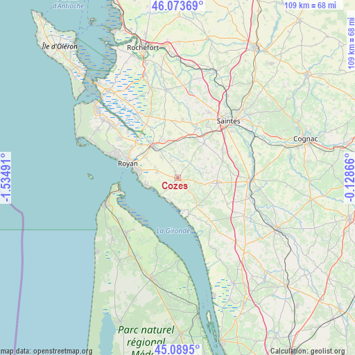
Cozes GPS coordinates[2]
45° 35' 1.5" North, 0° 49' 54.408" West
| Map corner | latitude | longitude |
|---|---|---|
| Upper-left | 46.07369°, | -1.53491° |
| Center: | 45.58375°, | -0.83178° |
| Lower-right: | 45.0895°, | -0.12866° |
| Map W x H: | 109.4×109.4 km | = 68×68mi |
| max Lat: | 51.07786° ⇑72.9% North |
| Cozes: | 45.58375° |
| min Lat: | ⇓27.1% South 41.3874° |
| min Long | Cozes | max Long |
| -5.08615° | -0.83178° | 9.52242° |
| W 13.3%⇐ | ⇒86.7% E |
Elevation
Elevation of Cozes is 39 m = 128 ft, and this is 154.7 m = 508 ft below average elevation for this country.
| Max E: |
2333 m = 7654 ft | 86.2% |
| Avg. | 193.7 m = 635 ft | |
| Cozes | 39 m = 128 ft | |
Min E: |
-1 m = -3 ft | 13.8% |
See also: France elevation on elevation.city.
Geographical zone
Cozes is located in North temperate zone (between Tropic of Cancer and the Arctic Circle). Distance of this North polar circle is 2332.7 km =1449.5 mi to North.| Distance of | km | miles | from Cozes |
|---|---|---|---|
| North Pole | 4938.6 | 3068.7 | to North |
| Arctic Circle | 2332.7 | 1449.5 | to North |
| Tropic Cancer | 2462.5 | 1530.1 | to South |
| Equator | 5068.4 | 3149.4 | to South |


Nearby cities:
15 places around Cozes: (largest is in red/bold)
• Arces
4.6 km =2.9 mi,  215°
215°
• Chenac-Saint-Seurin-d'Uzet
7.6 km =4.7 mi,  171°
171°
• Corme-Écluse
5.5 km =3.4 mi,  339°
339°
• Cravans
9.5 km =5.9 mi,  81°
81°
• Grézac
2.3 km =1.4 mi, 342°
• Le Chay
7.9 km =4.9 mi,  321°
321°
• Meschers-sur-Gironde
9.9 km =6.2 mi,  254°
254°
• Meursac
7.5 km =4.7 mi,  14°
14°
• Montpellier-de-Médillan
8.8 km =5.5 mi,  50°
50°
• Mortagne-sur-Gironde
11.9 km =7.4 mi,  162°
162°
• Rioux
11.1 km =6.9 mi,  58°
58°
• Saint-André-de-Lidon
6.8 km =4.2 mi,  74°
74°
• Saint-Romain-de-Benet
12 km =7.5 mi,  354°
354°
• Semussac
6.8 km =4.2 mi,  285°
285°
• Épargnes
5.2 km =3.2 mi,  154°
154°
Sources, notices
• [Note1] Compared only with cities in France existing in our database
• [Src1] Map data: © OpenStreetMap contributors (CC-BY-SA)
• [Src2] Other city data from geonames.org with taken over terms of usage.
• [Src3] Geographical zone / Annual Mean Temperature by Robert A. Rohde @ Wikipedia
