Sabres geodata
Sabres (Nouvelle-Aquitaine) is a populated place; located in France in Europe/Paris (GMT+2) time zone. With population of 1,393 people, there are 6634 cities with bigger population in this country. Compared to other cities in France, 85.9% of cities are located further ↑North; 85.9% of cities are located further →East and 69.2% of cities have higher elevation than Sabres. Note1
Administrative division(s):
- Level 1: Nouvelle-Aquitaine
- Level 2: Landes
- Level 3: Arrondissement de Mont-de-Marsan
- Level 4: Sabres


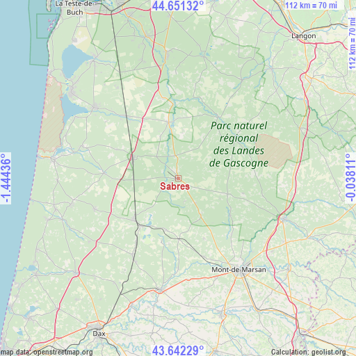
Sabres GPS coordinates[2]
44° 8' 56.256" North, 0° 44' 28.428" West
| Map corner | latitude | longitude |
|---|---|---|
| Upper-left | 44.65132°, | -1.44436° |
| Center: | 44.14896°, | -0.74123° |
| Lower-right: | 43.64229°, | -0.03811° |
| Map W x H: | 112.2×112.2 km | = 69.7×69.7mi |
| max Lat: | 51.07786° ⇑85.9% North |
| Sabres: | 44.14896° |
| min Lat: | ⇓14.1% South 41.3874° |
| min Long | Sabres | max Long |
| -5.08615° | -0.74123° | 9.52242° |
| W 14.1%⇐ | ⇒85.9% E |
Elevation
Elevation of Sabres is 80 m = 262 ft, and this is 113.7 m = 373 ft below average elevation for this country.
| Max E: |
2333 m = 7654 ft | 69.2% |
| Avg. | 193.7 m = 635 ft | |
| Sabres | 80 m = 262 ft | |
Min E: |
-1 m = -3 ft | 30.8% |
See also: France elevation on elevation.city.
Geographical zone
Sabres is located in North temperate zone (between Tropic of Cancer and the Arctic Circle). Distance of this Northern Tropic circle is 2303 km =1431 mi to South.| Distance of | km | miles | from Sabres |
|---|---|---|---|
| North Pole | 5098.2 | 3167.9 | to North |
| Arctic Circle | 2492.3 | 1548.6 | to North |
| Tropic Cancer | 2303 | 1431 | to South |
| Equator | 4908.9 | 3050.2 | to South |


Nearby cities:
15 places around Sabres: (largest is in red/bold)
• Arengosse
16.5 km =10.3 mi,  193°
193°
• Brocas
20.3 km =12.6 mi,  124°
124°
• Escource
23.4 km =14.5 mi,  274°
274°
• Geloux
20.4 km =12.7 mi,  156°
156°
• Labouheyre
16 km =9.9 mi,  296°
296°
• Labrit
16.4 km =10.2 mi,  107°
107°
• Luxey
21.7 km =13.5 mi,  54°
54°
• Morcenx
18.7 km =11.6 mi,  227°
227°
• Moustey
23.4 km =14.5 mi,  356°
356°
• Onesse-Laharie
28 km =17.4 mi,  249°
249°
• Pissos
18 km =11.2 mi,  350°
350°
• Rion-des-Landes
28 km =17.4 mi,  211°
211°
• Sore
23.3 km =14.5 mi,  33°
33°
• Ychoux
26.1 km =16.2 mi,  319°
319°
• Ygos-Saint-Saturnin
19.2 km =11.9 mi,  179°
179°
Sources, notices
• [Note1] Compared only with cities in France existing in our database
• [Src1] Map data: © OpenStreetMap contributors (CC-BY-SA)
• [Src2] Other city data from geonames.org with taken over terms of usage.
• [Src3] Geographical zone / Annual Mean Temperature by Robert A. Rohde @ Wikipedia
